Nations Online
All Countries in the World
Nations Online All Countries in the World | |
Home  |
___ Satellite View and Map of Benin (Republic of Benin) |
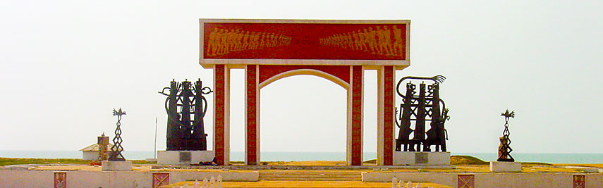 Door of no Return, a memorial arch south of Ouidah to commemorate the century long slave trade in West Africa. Image: rgrilo |
About Benin Satellite view is showing the tropical Sub-Saharan country of Benin, located on the south side of West Africa between Togo and Nigeria. From its northern border it extends 660 km to its coastline at the Bight of Benin (part of the Gulf of Guinea) in south. It is bordered by Burkina Faso in north west the Niger River marks the border with Niger, in north. Satellite view is showing the tropical Sub-Saharan country of Benin, located on the south side of West Africa between Togo and Nigeria. From its northern border it extends 660 km to its coastline at the Bight of Benin (part of the Gulf of Guinea) in south. It is bordered by Burkina Faso in north west the Niger River marks the border with Niger, in north.The country occupies an area of 112,622 km² making it slightly larger than Bulgaria, or slightly smaller than the U.S. state of Pennsylvania. Until 1975 Benin was known as Dahomey. 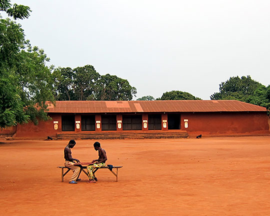 Royal Palaces of Abomey Image: Cordelia Persen There are more than 40 ethnic groups in Benin, major groups are the Fon (in the south), the Yoruba (in the southeast near Nigeria), the Dendi people (in central and north), the Fulani (in the northeast), and the Betammaribe (in the Atacora Range). Official Capital city is Porto-Novo, while Cotonou is the economic capital of Benin and its largest city. Other major urban centers are Abomey-Calavi, a suburban of Cotonou; Djougou, an important market town and the commercial capital of the Atacora-Donga region in northwestern Benin; Parakou, most populous city in eastern Benin and the terminus of the railway to Cotonou. Tchaourou (Saworo), a major, mainly agricultural town in the Borgou Department . The map shows Benin with cities, towns, expressways, main roads and streets. To find a location use the form below. To view just the map, click on the "Map" button. |
|
| To find a location type: street or place, city, optional: state, country. |
Local Time Benin:
Wednsday-April-17 03:30
UTC/GMT +1 hours |
One World - Nations Online .:. let's care for this planet Promote that every nation assumes responsibility for our world. Nations Online Project is made to improve cross-cultural understanding and global awareness. More signal - less NOISE |
| Site Map
| Information Sources | Disclaimer | Copyright © 1998-2023 :: nationsonline.org |

