Nations Online
All Countries in the World
Nations Online All Countries in the World | |
Home  |
___ Satellite View and Map of Liberia |
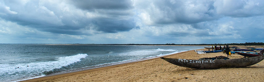 Beach of Robertsport, a town in western Liberia on Cape Mount peninsula, about 35 km by road from the Sierra Leone border, it is the capital of Grand Cape Mount county. Image: jbdodane |
Searchable Map and Satellite View of Liberia using Google Earth DataSatellite view is showing Liberia, the "Land of the Free" a country on the North Atlantic coast of West Africa, known first as the Pepper Coast and later as the Grain Coast. Liberia is situated between Côte d’Ivoire and Sierra Leone. it is also bordered by Guinea in north.With an area of 111,369 km² (43,000 sq mi) Liberia is somewhat larger than Bulgaria or slightly larger than the U.S. state of Tennessee. In 1822, the American Colonization Society (ACS) began sending African-American volunteers to the Grain Coast to establish a colony for freed African Americans. The problem was, many of them were of mixed race and educated in American culture; they did not identify with the indigenous natives of the tribes they encountered. The ACS, a private organization supported by prominent American politicians such as Abraham Lincoln, Henry Clay, and James Monroe, believed repatriation of free blacks was preferable to widespread emancipation of slaves. Similar state-based organizations established colonies in Mississippi-in-Africa and the Republic of Maryland, which were later annexed by Liberia. Today Liberia has a population of about 4.5 million people (in 2015). Capital city is Monrovia, named after James Monroe, the fifth President of the United States (1817–1825). Spoken languages are English (official) and an English-based pidgin plus, over 20 indigenous languages. Liberia is one of the poorest countries in the world with a high unemployment rate (85%) and high corruption. The map shows Liberia with cities, towns, expressways, main roads and streets. To find a location use the form below. |
||
| To find a location type: street or place, city, optional: state, country. | Local Time Liberia:
Friday-April-19 03:29
Time Zone: no time offset of GMT/UTC 0h |
|
|
φ Latitude, λ Longitude (of Map center; move the map to see coordinates): , |
||||||
| Google Maps: Searchable Map of Republic of Liberia. | Bookmark/share this page |
|||||
| More about Liberia: Cities: Country: Continent: | Weather Conditions Monrovia at Roberts International Airport
|
Related Consumer Information:
| ||||
Searchable Maps of other Countries in West Africa: Benin | Burkina Faso | Cape Verde | Côte d'Ivoire | Gambia | Ghana | Guinea | Guinea-Bissau Mali | Mauritania | Niger | Nigeria | Senegal | Sierra Leone | Togo |
||||||
Map Help [ show ] |
||||||
One World - Nations Online .:. let's care for this planet Promote that every nation assumes responsibility for our world. Nations Online Project is made to improve cross-cultural understanding and global awareness. More signal - less NOISE |
| Site Map
| Information Sources | Disclaimer | Copyright © 1998-2023 :: nationsonline.org |

