Nations Online
All Countries in the World
Nations Online All Countries in the World | |
Home  |
___ Satellite View and Map of the City of Constanta (Constanţa) |
About Constanta
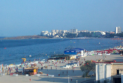 Constanta, Mamaia-Beach, Romania's largest and most popular beach resort. Constanta is the capital of Constanta County, located in the Dobruja region southeast of the country on the shores of the Black Sea. Romania's oldest city, founded around 600 BC, was a Greek colony known then as Tomis, the settlement was captured by the Romans in 29 BC. The Roman poet Ovid (43 BC-17) was banished to the town by Emperor Augustus, in 8 AD. A statue of Ovid stands in the Ovid Square (Piața Ovidiu) of Constanța, in front of the History Museum. Today the city has a population of about 280,000 inhabitants, about 420,000 people live in the metropolitan area. Immediately north-east of Constanţa situated is Mamaia, Romania's largest and most popular beach resort. The Map shows a city map of Constanta with expressways, main roads and streets, Constanta International Airport (IATA code: CND) about 33 km (20.5 mi) by road (via DN2A/E60) northwest of the city. To find a location use the form below. To view just the map, click on the "Map" button. |
|
| To find a location type: street or place, city, optional: state, country. |
Local Time Constanta:
Tuesday-May-7 20:59
Standard Time Zone (EET): UTC/GMT +2 hEEST (Daylight Saving Time) in use from end of March until end of October: time zone offset: UTC/GMT +3 h |
|
φ Latitude, λ Longitude (of Map center; move the map to see coordinates): , |
||||||
| Sorry! Google's pricing policy has made it impossible for us to continue showing Google Maps. We apologize for any inconvenience. Google Map: Searchable map/satellite view of Constanta and Mamaia, Romania City Coordinates: 44°10.4′N 28°38.3′E |
Bookmark/share this page |
|||||
| More about Romania: Cities: Country: Continent: Political Map of the Balkans. Political Map of the Mediterranean Region. |
Weather Conditions Constanta
External Links: Constanta Official website of the City of Constanta. Tourism Constanta Romanian National Tourist Office with information about Constanta and the Romanian Black Sea Resorts. Wikipedia: Constanţa Wikipedia article about Constanţa. |
Related Consumer Information:
|
||||
Other Cities in Eastern Europe: Bratislava | Bucharest | Budapest | Chisinau | Kiev | Minsk | Moscow | Prague | Sofia | Warsaw Maps of other countries and regions in Central and Eastern Europe Belarus Map, Bulgaria Map, Czech Republic Map, Hungary Map, Moldova Map, Poland Map, Romania Map, Slovakia Map, Ukraine Map Administrative Maps of other countries and regions in Central and Eastern Europe Hungary Administrative Map, Poland Administrative Map, Ukraine Administrative Map Interactive Maps of other countries and regions in Central and Eastern Europe Belarus Interactive Map, Bulgaria Interactive Map, Czech Interactive Republic Map, Hungary Interactive Map, Moldova Interactive Map, Poland Interactive Map, Slovakia Interactive Map, Ukraine Interactive Map |
||||||
Map Help [ show ] |
||||||
One World - Nations Online .:. let's care for this planet Promote that every nation assumes responsibility for our world. Nations Online Project is made to improve cross-cultural understanding and global awareness. More signal - less NOISE |
| Site Map
| Information Sources | Disclaimer | Copyright © 1998-2023 :: nationsonline.org |

