
| Home |
|
|
|
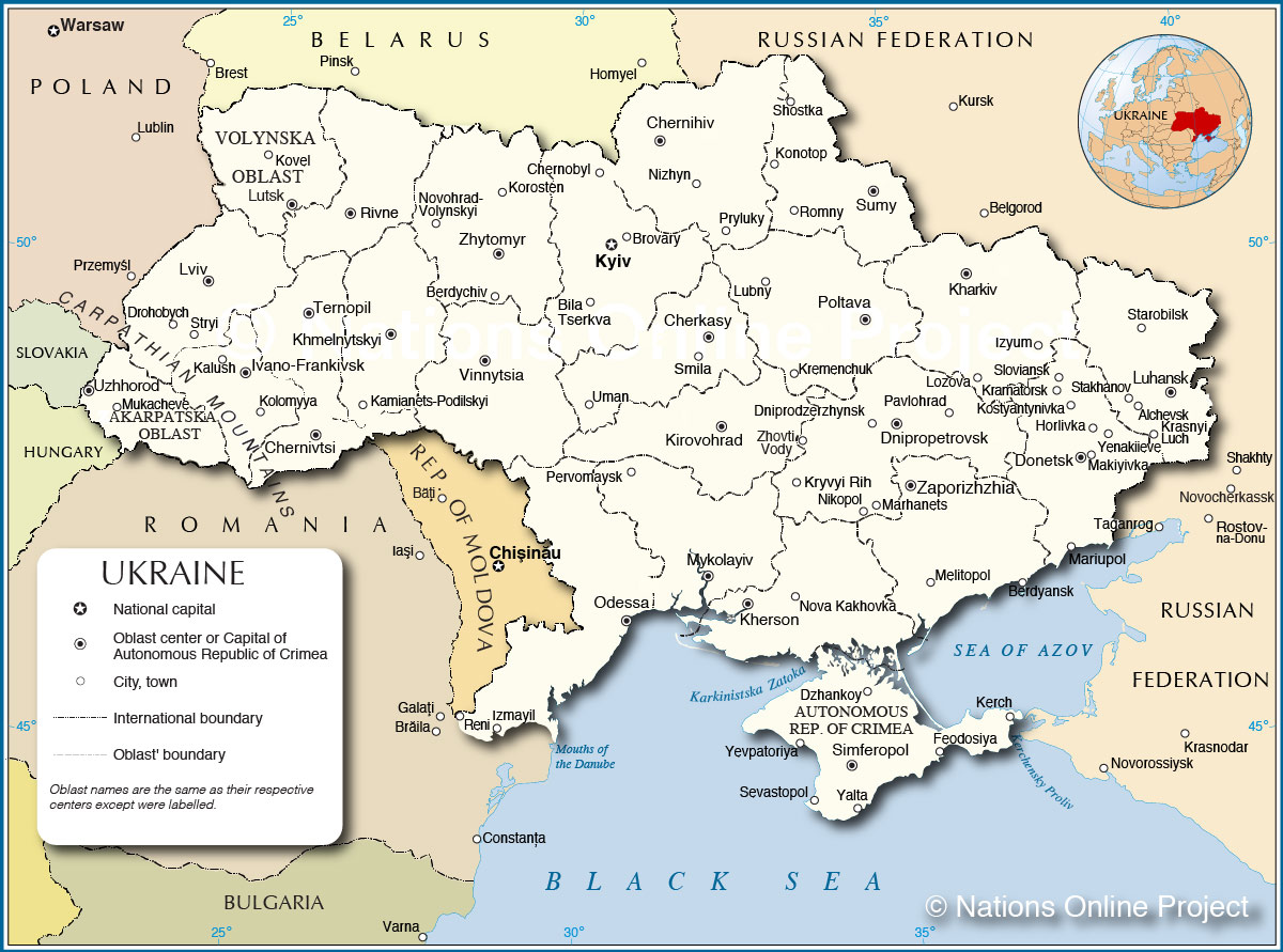
___ Administrative Map of Ukraine | |
About Ukraine |
|
| Map is showing Ukraine, the country in eastern Europe, north of the Black Sea and the Sea of Azov. The country is known as the breadbasket of Europe. With an area of 600,000 km² it is the second largest country in Europe
after Russia, twice the size of Italy or slightly smaller than than the U.S. state of Texas. Ukraine is bordered by Belarus, Hungary, Moldova, Poland, Romania, Russia, and Slovakia, its capital is Kiev. Depicted on the map are the Ukraine with surrounding countries, international and administrative boundaries, and major cities. Ukraine is subdivided into twenty-four oblasts (provinces) and one autonomous republic, the Autonomous Republic of Crimea. There are two cities with special status: Kiev and Sevastopol. For a list of Ukraine's oblasts see below. |
 Bookmark/share this page |
 One World - Nations Online all countries of the world |
|
|
||
 Administrative Map of Ukraine |
||
| Ukrainian Oblasts: (Oblast names are the same as their respective administrative centers (capitals)) Cherkasy, Chernihiv, Chernivtsi, Dnipropetrovsk, Donetsk, Ivano-Frankivsk, Kharkiv, Kherson, Khmelnytskyi, Kiev, Kirovohrad, Luhansk, Lviv, Mykolaiv, Odessa, Poltava, Rivne, Sumy, Ternopil, Vinnytsia, Volyn (its administrative center is Lutsk), Zakarpattia, Zaporizhia, and Zhytomyr. Ukrainen cities: The map shows the location of following Ukrainian cities. Largest cities (with a population of over 1 million): Kyiv (Kiev), Kharkiv, Dnipropetrovsk, Odesa (Odessa), and Donetsk. Other Cities and towns: Alchevsk, Berdyansk, Berdychiv, Bila Tserkva, Brovary, Cherkasy, Chernihiv, Chernivtsi, Chornobyl (Chernobyl), Dniprodzerzhynsk, Drohobych, Dzhankoy, Feodosiya, HorlivkaIzmayil, Ivano-Frankivsk, Kalush, Kerch, Kherson, Khmelnytskyi, Kirovohrad, Kolomyya, Konotop, Korosten, Kostyantynivka, Kovel, Kramatorsk, Krasnyi Luch, Kremenchuk, Kryvyi Rih, LozovaIzyum, Lubny, Luhansk, Lutsk, Lviv, Makiyivka, Marhanets, Mariupol, Melitopol, Mukacheve, Mykolayiv, Nikopol, Nizhyn, Nova Kakhovka, Novohrad-Kamianets-Podilskyi, Pavlohrad, Pervomaysk, Poltava, Pryluky, Reni, Rivne, Romny, Sevastopol , Shostka, Simferopol, Sloviansk, Smila, Stakhanov, Starobilsk, Stryi, Sumy, Ternopil, Uman, Uzhhorod, Vinnytsia, Volynskyi, Yalta, Yenakiieve, Yevpatoriya, Zaporizhzhia, Zhovti Vody, Zhytomyr. |
| More about Ukraine: Cities: Country: Continent: |
Current Weather Conditions Kiev:
|
Current Weather Conditions Simferopol (Crimea):
|
Related Consumer Information: |
||||||||
Maps of other countries and regions in Central and Eastern Europe Belarus Map, Bulgaria Map, Czech Republic Map, Hungary Map, Moldova Map, Poland Map, Romania Map, Slovakia Map Interactive Maps of other countries and regions in Central and Eastern Europe Belarus Interactive Map, Bulgaria Interactive Map, Czech Interactive Republic Map, Hungary Interactive Map, Moldova Interactive Map, Poland Interactive Map, Romania Interactive Map, Slovakia Interactive Map Other Cities in Eastern Europe: Bratislava | Bucharest | Budapest | Chisinau | Minsk | Moscow | Prague | Sofia | Warsaw Countries and Territories of Europe |
One World - Nations Online .:. let's care for this planet Every nation is responsible for the current state of our world. |
| Site Map
| Information Sources | Disclaimer: Privacy Policy, etc. Contact: [email protected] | Copyright © 1998-2021 :: nationsonline.org |

