Nations Online
All Countries in the World
Nations Online All Countries in the World | |
Home  |
___ Famous Landmarks - Satellite View of Angkor Archaeological Park |
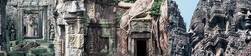 Reliefs at Ta Prohm Tempel Site, and Bayon Tempel (right image), Angkor Wat, Angkor. Images: Valeska Gehrmann |
About AngkorSatellite view is showing Angkor complex, with the world famous Khmer temple of Angkor Wat inThe ruins of Angkor are located to the north of Tonle Sap lake and south of the Kulen Hills, near the city of Siem Reap. Angkor is one of the most important archaeological sites in South-East Asia. The Angkor Archaeological Park contains the magnificent remains of the different capitals of the Khmer Empire, (9th to the 15th century), including the temples of Angkor Wat, Angkor Thom, and the Bayon Temple. Today it is a UNESCO World Heritage Site Use the Zoom out to find more archaeological sites in Cambodia like the Koh Ker, one of the temporary capitals of the Khmer Empire, or the 'trilogies of mountains' sites of Phnom Bakheng, Phnom Bok and Phnom Krom. |
|
φ Latitude, λ Longitude (of Map center; move the map to see coordinates): , |
|
| Google Earth: Satellite View and Map of Angkor Archaeological Park, Siem Reap, Cambodia. (Make sure 3D Buildings is checked in the Layers panel in Google Earth, eventually uncheck the Terrain layer.) |
Bookmark/share this page |
| Angkor Coordinates (WGS 84): 13° 26′ 0″ N, 103° 50′ 0″ E |
|
| previous landmark: Great Wall of China | next landmark: Acropolis of Athens, Greece |
More about Cambodia: Landmarks: Cities: Country: Cambodia key statistical data. Continent: External links: Greater Angkor Project International, multidisciplinary research programme interested in the decline of urbanism at Angkor. UNESCO World Heritage: Angkor Archaeological Park Angkor entry at UNESCO World Heritage center. Wikipedia: Angkor Wikipedia article about Angkor. |
Explore more:
Related Consumer Information:
|
| Searchable Maps of other Countries in South East Asia: Brunei, Cambodia, Indonesia, Laos, Malaysia, Myanmar (Burma), Philippines, Singapore, Thailand, Vietnam All Countries and Territories of Asia |
Map Help [ show ] |
One World - Nations Online .:. let's care for this planet Made to improve cross-cultural understanding, global awareness, and cultivating a cosmopolitan consciousness. |
 |
|
| Site Map
| Information Sources | Disclaimer: Privacy Policy, etc. | Contact:
[email protected]
Copyright © 1998-2017 :: nationsonline.org | ||
