Nations Online
All Countries in the World
Nations Online All Countries in the World | |
Home  |
___ Satellite View and Map of Guatemala |
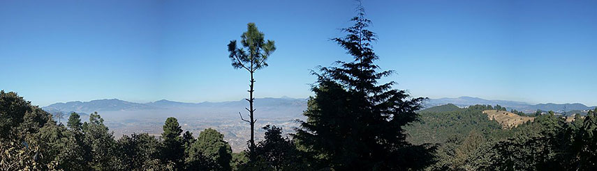 The Highlands in Guatemala, view of the Sierra Madre de Chiapas, to the left is the Siete Orejas volcano. The cone of the Tajumulco volcano is visible in the far distance. - Image: Simon Burchell |
Searchable Map and Satellite View of Guatemala using Google Earth DataSatellite view is showing the Central American country bordering the Gulf of Honduras (Caribbean Sea) and the North Pacific Ocean. Capital city is Guatemala City.Countries with international borders to Guatemala are Belize, El Salvador, Honduras, and Mexico. More about Guatemala... The map shows Guatemala with cities, towns, expressways, main roads and streets. To find a location use the form below. To view just the map, click on the "Map" button. |
|
| To find a location type: street or place, city, optional: state, country. |
Local Time Guatemala:
Wednsday-April-24 10:23
Time zone: Central Standard Time (CST) :: UTC/GMT -6 hours
|
|
φ Latitude, λ Longitude (of Map center; move the map to see coordinates): , |
||||||
| Google Maps: Searchable Map of República de Guatemala. |
Bookmark/share this page |
|||||
| More about Guatemala: Cities: Country: Guatemala key statistical data. Continent: |
Current Weather Conditions Guatemala City
|
Related Consumer Information:
|
||||
| Searchable Maps of other Countries of Central America: Belize, Costa Rica, El Salvador, Guatemala, Honduras, Nicaragua, Panama Country Profiles: Countries and Territories of The Americas |
||||||
Map Help [ show ] |
||||||
One World - Nations Online .:. let's care for this planet Promote that every nation assumes responsibility for our world. Nations Online Project is made to improve cross-cultural understanding and global awareness. More signal - less NOISE |
| Site Map
| Information Sources | Disclaimer | Copyright © 1998-2023 :: nationsonline.org |

