Nations Online
All Countries in the World
Nations Online All Countries in the World | |
Home  |
___ Satellite View and Map of Panama (República de Panamá) |
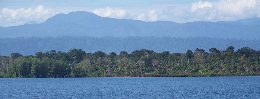 Biosphere Reserve 'La Amistad' area in Bocas del Toro Province, Panama. Tropical rainforests cover most of the area. La Amistad National Park |
About PanamaMap is showing Panama on the isthmus, the natural land bridge between the continents of North America and South America.Panama borders Costa Rica to the west, Colombia to the east, the Caribbean Sea, part of the Atlantic Ocean to the north and the Gulf of Panama, part of Pacific Ocean in the south. The Atlantic and the Pacific Ocean are connected by the Panama Canal. Capital city is Panama City, official language is Spanish. In Panama ends the Pan-American Highway, a system of roads of about 48,000 km (30,000 mi) long, from Prudhoe Bay, Alaska in the USA to Ushuaia in Argentina -- from North, through Central, and South America. But there is a gap, the so called Darién Gap, a strech of undeveloped swampland and forest within Panama's Darién Province in Central America and the northern part of Colombia's Chocó Department in South America. The gap is just about 160 km (99 mi) long, and it's just unbelievable that there is no surface transport system on the only overland link between South and Central America. But many people, groups, indigenous populations, and governments are opposed to completing the Darién portion of the highway. More about Panama... The map shows Panama with cities, towns, expressways, main roads and streets. To find a location use the form below. To view just the map, click on the "Map" button. |
||
| To find a location type: street or place, city, optional: state, country. | Local Time Panama:
Wednsday-May-1 2024 17:09
Standard Time Zone: Eastern (EST), UTC/GMT -5 hours |
|
|
φ Latitude, λ Longitude (of Map center; move the map to see coordinates): , |
||||||
| Google Maps: Searchable Map of Republic of Panama. |
Bookmark/share this page |
|||||
| More about Panama: Landmarks: Cities: Country: Continent: | Current Weather Panama City
|
Related Consumer Information:
|
||||
| Searchable Maps of other Countries of Central America: Belize, Costa Rica, El Salvador, Guatemala, Honduras, Nicaragua Countries and Territories of The Americas |
||||||
Map Help [ show ] |
||||||
One World - Nations Online .:. let's care for this planet Promote that every nation assumes responsibility for our world. Nations Online Project is made to improve cross-cultural understanding and global awareness. More signal - less NOISE |
| Site Map
| Information Sources | Disclaimer | Copyright © 1998-2023 :: nationsonline.org |

