Nations Online
All Countries in the World
Nations Online All Countries in the World | |
Home  |
___ Satellite View and Map of Guatemala City (La Nueva Guatemala de la Asunción) |
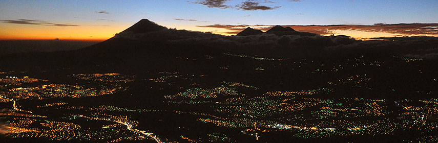 Guatemala City at night, the beauty of the image is deceiving, 60 per cent of Guatemala's population is poor. Image: chensiyuan |
About Guatemala City (Guate) Satellite view is showing Guatemala City, the national capital of Satellite view is showing Guatemala City, the national capital of Guatemala City is a planned city, it was founded in 1776 to replace the former capital, Antigua Guatemala, which was partially destroyed by the Santa Marta earthquakes in 1773. The city was laid out with streets running north-south and east-west, with a central square and three smaller squares. The city was destroyed again by the 1917 earthquake. After reconstruction the city grew in a large horizontal expansion due to a decade-long migration from the rural areas into its metropolitan space, with precarious conditions for many of its inhabitants. Many houses in the "settlements" are made of rusty corrugated iron, cardboard and plastic. Poverty and resulting social insecurity continues to be one of the most serious problems in Guatemala, which is especially generated in the capital and its urban areas. Today it is the largest city in Central America and in the Caribbean Basin, it has an estimated population of more than 3 million people. It is Guatemala's prime city, the center of political, economic and industrial power in the country. Spoken languages are Spanish and various Mayan languages. The map shows a city map of Guatemala City with expressways, main roads and streets, and the location of La Aurora International Airport (IATA code: GUA), about 6 km (4 mi) south of Guatemala City's center. Zoom out to find the location of Pacaya volcano about 30 kilometers (19 mi) south of Guatemala City. To find a location use the form below. |
|
| To find a location type: street or place, city, optional: state, country. |
Local Time Guatemala:
Tuesday-July-7 22:02
Time zone: Central Standard Time (CST) UTC/GMT -6 hours
|
|
φ Latitude, λ Longitude (of Map center; move the map to see coordinates): , |
||||||
| Searchable map/satellite view of Guatemala City, Guatemala. City Coordinates: 14°37′22 N 90°31′53 W |
Bookmark/share this page |
|||||
| More about Guatemala: Country: Guatemala key statistical data. Continent: |
Current Weather Conditions Guatemala City
External Link Wikipedia: Guatemala City The case of Guatemala City |
Related Consumer Information:
|
||||
| Searchable Maps of other Capital Cities in Central America: Belmopan, Managua, Panama City, San José, San Salvador, Tegucigalpa Searchable Maps of other Countries of Central America: Belize, Costa Rica, El Salvador, Guatemala, Honduras, Nicaragua, Panama |
||||||
Map Help [ show ] |
||||||
One World - Nations Online .:. let's care for this planet Promote that every nation assumes responsibility for our world. Nations Online Project is made to improve cross-cultural understanding and global awareness. More signal - less NOISE |
| Site Map
| Information Sources | Disclaimer | Copyright © 1998-2024:: nationsonline.org |

