Nations Online
All Countries in the World
Nations Online All Countries in the World | |
Home  |
___ Satellite View and Map of Nicaragua |
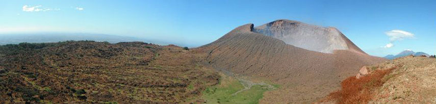 Telica volcano, one of Nicaragua's most active volcanoes - Image: Josef87 |
Searchable Map and Satellite View of Nicaragua using Google Earth DataMap is showing the Central American country with coastlines at both, the Caribbean Sea and the North Pacific Ocean. Countries with international borders to Nicaragua are Costa Rica and Honduras.Nicaragua's landscape offers a narrow Pacific coastal plain, interrupted by volcanoes, and extensive Atlantic coastal plains which rise to central interior mountains. In south Lake Nicaragua, the largest freshwater lake in Central America.The country's climate is tropical in lowlands, cooler in highlands. Read more about the geography of Nicaragua... Capital city of Nicaragua is Managua. Spoken languages are Spanish (official), and several regional recognized languages. The map shows Nicaragua with cities, towns, expressways, main roads and streets. To find a location use the form below. To view the terrain, use on the "Terrain" option under the map button. |
|
| To find a location type: street or place, city, optional: state, country. | Local Time Nicaragua:
Friday-April-19 22:50
Time zone: Central Standard Time: UTC/GMT -6 hours |
|
φ Latitude, λ Longitude (of Map center; move the map to see coordinates): , |
||||||
| Google Maps: Searchable Map of Republic of Nicaragua. |
Bookmark/share this page |
|||||
| More about Nicaragua: Cities: Country: Continent: |
Current Weather Conditions Managua:
|
Related Consumer Information:
|
||||
| Searchable Maps of other Countries of Central America: Belize, Costa Rica, El Salvador, Guatemala, Honduras, Panama Country Profiles: Countries and Territories of The Americas |
||||||
Map Help [ show ] |
||||||
One World - Nations Online .:. let's care for this planet Promote that every nation assumes responsibility for our world. Nations Online Project is made to improve cross-cultural understanding and global awareness. More signal - less NOISE |
| Site Map
| Information Sources | Disclaimer | Copyright © 1998-2023 :: nationsonline.org |

