Nations Online
All Countries in the World
Nations Online All Countries in the World | |
Home  |
___ Satellite View and Map of the City of Tegucigalpa (Tegus) |
Searchable Map and Satellite View of Tegucigalpa using Google Earth Data Satellite view is showing Tegucigalpa, largest city and since 1880 the national capital of Satellite view is showing Tegucigalpa, largest city and since 1880 the national capital of The city is located in the southern-central highland region of Honduras on a deforested mountain basin at the foot of Picacho hill. The Choluteca river crosses the city from south to north separating Tegucigalpa and its sister city Comayagüela. Tegucigalpa and Comayagüela together form Hondura's Central District (Distrito Central), the governing body of the nation. The colonial city was founded by Spanish settlers in the late 16th century. The Dolores Church (1735), the San Miguel Cathedral (1765), the Casa de la Moneda (1780), and the Immaculate Conception Church (1788) were some of the first important buildings constructed. Today Tegucigalpa has a population of about 1.2 million inhabitants in its metropolitan area. Official language is Spanish. The capital's infrastructure has not kept pace with the population growth. Deficient urban planning, a densely condensed urbanization, and poverty are ongoing problems not only in the city. The current road infrastructure is unable to efficiently handle the almost half a million vehicles which wreak havoc on a daily basis. The city is home to the National Autonomous University of Honduras The Map shows a city map of Tegucigalpa with expressways, main roads and streets, Toncontín International Airport To find a location use the form below. |
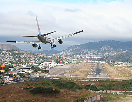 A 747 plane approach for landing at Toncontín International Airport, one of the more dangerous airports in the world. The approach to the airport is considered to be one of the most difficult. Image: enrique galeano morales Bookmark/share this page |
| To find a location type: street or place, city, optional: state, country. |
Local Time Tegucigalpa:
Thursday-April-18 23:19
Time zone: Central Standard Time (CST) UTC/GMT -6 hours
|
|
φ Latitude, λ Longitude (of Map center; move the map to see coordinates): , |
||||||
| Sorry! Google's pricing policy has made it impossible for us to continue showing Google Maps. We apologize for any inconvenience. Google Map: Searchable map/satellite of Tegucigalpa and Comayagüela, Republic of Honduras. |
||||||
| City Coordinates: 14°6′N 87°13′W |
||||||
| More about Honduras: Cities: Country: Honduras Key Statistical Data. Continent: |
Current Weather Conditions Tegucigalpa
External Links: Tegucigalpa Official Municipality website, (offline) El Heraldo Local news (in spanish) Wikipedia: Tegucigalpa |
Related Consumer Information:
|
||||
| Searchable Maps of other Capital Cities in Central America: Belmopan, Guatemala City, Managua, Panama City, San José, San Salvador Searchable Maps of other Countries of Central America: Belize, Costa Rica, El Salvador, Guatemala, Honduras, Nicaragua, Panama |
||||||
Map Help [ show ] |
||||||
One World - Nations Online .:. let's care for this planet Promote that every nation assumes responsibility for our world. Nations Online Project is made to improve cross-cultural understanding and global awareness. More signal - less NOISE |
| Site Map
| Information Sources | Disclaimer | Copyright © 1998-2023 :: nationsonline.org |

