Nations Online
All Countries in the World
Nations Online All Countries in the World | |
Home  |
___ Satellite View and Map of the City of Managua, Nicaragua |
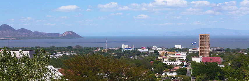 Managua seen from Loma de Tiscapa. - Image: Haakon S. Krohn |
Searchable Map and Satellite View of Managua using Google Earth Data Satellite view is showing Managua, the national capital of Satellite view is showing Managua, the national capital of Nicaragua's largest city has a population of about 1 million inhabitants, almost 2.5 million people live in the metropolitan area. Spoken languages are Spanish (official), and several regional languages. Some of Managua's landmarks are the Plaza de la Revolución, Managua's historical center on the shores of Lake Xolotlan. The Old St James Cathedral was designed and shipped from Belgium in 1920. Rubén Dario National Theater, Nicaragua's most important theater. The National Palace of Culture, Managua's oldest undamaged building houses the National Archive, the National Library, and the National Museum. Tiscapa Lagoon (Laguna Tiscapa), a lagoon of volcanic origin lies within the Tiscapa Lagoon Natural Reserve, just south of the Managua's Historical Center. Just zoom in (+) to see the center of Managua, the old downtown to the north of Laguna Tiscapa with the Plaza de la Revolución, the Presidential Palace (Casa Presidencial o Casa de los Pueblos), the Catedral de Santiago, (the old cathedral), the Rubén Dario National Theater and the Museum National Palace of Culture. The map shows a city map of Managua with expressways, main roads and streets, and the location of Managua International Airport (IATA code: MGA) in the eastern part of the city. To find a location use the form below. To view just the map, click on the "Map" button. |
|
| To find a location type: street or place, city, optional: state, country. | Local Time Nicaragua:
Monday-April-22 22:01
Time zone: Central Standard Time (CST) UTC/GMT -6 hours |
|
φ Latitude, λ Longitude (of Map center; move the map to see coordinates): , |
||||||
| Google Earth: Searchable map/satellite view of Managua, Nicaragua. City Coordinates: 12°8′11″N 86°15′5″W |
Bookmark/share this page |
|||||
| More about Nicaragua: Country: Continent: External Links: Managua (Official municipality website of Managua; in Spanish) Wikipedia: Managua | Current Weather Conditions Managua:
|
Related Consumer Information:
|
||||
| Searchable Maps of other Capital Cities in Central America: Belmopan, Guatemala City, Panama City, San José, San Salvador, Tegucigalpa Searchable Maps of other Countries of Central America: Belize, Costa Rica, El Salvador, Guatemala, Honduras, Nicaragua, Panama |
||||||
Map Help [ show ] |
||||||
One World - Nations Online .:. let's care for this planet Promote that every nation assumes responsibility for our world. Nations Online Project is made to improve cross-cultural understanding and global awareness. More signal - less NOISE |
| Site Map
| Information Sources | Disclaimer | Copyright © 1998-2023 :: nationsonline.org |

