Nations Online
All Countries in the World
Nations Online All Countries in the World | |
Home  |
___ Satellite View and Map of the City of San Salvador, El Salvador |
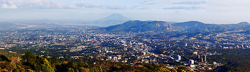 Panorama view of the city of San Salvador. |
About San Salvador Satellite view is showing San Salvador, second largest city in Central America and the national capital of Satellite view is showing San Salvador, second largest city in Central America and the national capital of The city is located west of Lake Ilopango, El Salvador's largest lake. West of the city San Salvador mountain (also known as Quetzaltepec), a 1,900 m high stratovolcano which erupted last time in November 1917, dominates the landscape. The country's largest city is El Salvador's most important political, cultural, educational and financial center. The city has a population of about 540,000 inhabitants, 2.4 million people live in its metropolitan area. Spanish is the official language. The city is home to cultural institutions like the oldest theatre in Central America, the Teatro Nacional de El Salvador, and educational institutions like the main campus of the University of El Salvador The map shows a city map of San Salvador with expressways, main roads and streets, zoom out to find the location of Cuscatlan International Airport (IATA code: SAL) about 40 km (25 miles) by road, via Autopista Comalapa/RN-5, south east of the city. To find a location use the form below. |
|
| To find a location type: street or place, city, optional: state, country. | Local Time El Salvador:
Monday-June-29 10:01
Time zone: Central Standard Time (CST) UTC/GMT -6 hours |
|
φ Latitude, λ Longitude (of Map center; move the map to see coordinates): , |
||||||
| Google Maps: Searchable map/satellite view of San Salvador, El Salvador. City Coordinates: 13°41′24″N 89°11′24″W |
Bookmark/share this page |
|||||
| More about El Salvador: Country: Continent: External Links: Alcaldía Municipal de San Salvador (Official website of San Salvador) Wikipedia: San Salvador | Current Weather Conditions San Salvador: (Weather station is in Nueva Ocotepeque a city in south west Honduras, north of San Salvador).
|
Related Consumer Information:
|
||||
| Searchable Maps of other Capital Cities in Central America: Belmopan, Guatemala City, Managua, Panama City, San José, Tegucigalpa Searchable Maps of other Countries of Central America: Belize, Costa Rica, El Salvador, Guatemala, Honduras, Nicaragua, Panama |
||||||
Map Help [ show ] |
||||||
One World - Nations Online .:. let's care for this planet Promote that every nation assumes responsibility for our world. Nations Online Project is made to improve cross-cultural understanding and global awareness. More signal - less NOISE |
| Site Map
| Information Sources | Disclaimer | Copyright © 1998-2024:: nationsonline.org |

