Nations Online
All Countries in the World
Nations Online All Countries in the World | |
Home  |
___ Satellite View and Map of the City of San Pedro Sula |
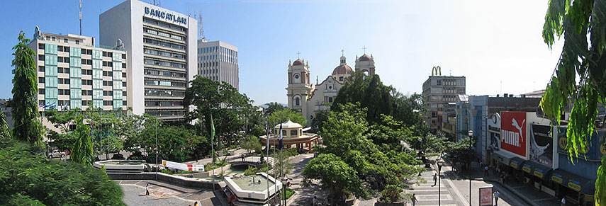 Panoramic view of Downtown San Pedro Sula, Parque Central with San Pedro Sula Cathedral in center. Image: Gervaldez |
About San Pedro Sula The satellite view shows San Pedro Sula, second largest city in The satellite view shows San Pedro Sula, second largest city in The city was founded in 1536 by the Spanish east of its present site, this colonial city benefited initially from the growth of bananas and its sugar plantations it is today the industrial center of Honduras. San Pedro Sula has a population of about 800 000 inhabitants in its metropolitan area. Official language is Spanish. Welcome to 'The Most Violent City On Earth'. Honduras has a murder rate of 85.5 per 100,000 residents, compared with 56 in Venezuela, 4.78 in the US and 1.2 in the UK. In San Pedro Sula, the rate is 171, reportedly the highest in the world outside a war zone. Honduras is caught in a vortex of crime – drug trafficking, gang wars, political upheaval and fierce land disputes matched by equal doses of impunity and corruption. (The Guardian). In 2015 the US Department of State continues to warn U.S. citizens that the level of crime and violence in Honduras remains critically high, although it has declined in the past two years. (US Department of State) The Map shows a city map of San Pedro Sula with expressways, main roads and streets, Ramón Villeda Morales International Airport (IATA Code: SAP) is situated in south east. To find a location use the form below. |
|
| To find a location type: street or place, city, optional: state, country. |
Local Time San Pedro Sula:
Wednsday-April-24 11:09
UTC/GMT -6 hours
|
|
φ Latitude, λ Longitude (of Map center; move the map to see coordinates): , |
||||||
| Searchable map/satellite of San Pedro Sula, Republic of Honduras. |
Bookmark/share this page |
|||||
| City Coordinates: 15°30′0″N 88°2′0″W |
||||||
| More about Honduras: Cities: Country: Honduras Key Statistical Data. Continent: External Links Wikipedia: San Pedro Sula |
Current Weather Conditions San Pedro Sula Airport
|
Related Consumer Information:
|
||||
| Searchable Maps of other Countries of Central America: Belize, Costa Rica, El Salvador, Guatemala, Nicaragua, Panama Country Profiles: Countries and Territories of The Americas |
||||||
Map Help [ show ] |
||||||
One World - Nations Online .:. let's care for this planet Promote that every nation assumes responsibility for our world. Nations Online Project is made to improve cross-cultural understanding and global awareness. More signal - less NOISE |
| Site Map
| Information Sources | Disclaimer | Copyright © 1998-2023 :: nationsonline.org |

