Nations Online
All Countries in the World
Nations Online All Countries in the World | |
Home  |
___ Administrative Map of Kazakhstan |
| Administrative Divisions of Kazakhstan Kazakhstan is divided into 14 provinces (Kazakh: облыстар, oblıstar) or regions (sing. oblast (область), pl. oblasttar (областтар)). Astana, and the largest city Almaty are administratively independent cities with a status comparable to an oblast. Baikonur (Qyzylorda province) has a special status because it's being leased to Russia with Baikonur cosmodrome until 2050. Oblast (capitals in parentheses): Akmola (Kokshetau), Aqtöbe (Aktobe), Almaty Province (Taldykorgan), East Kazakhstan (Oskemen), Jambyl (Taraz), Karagandy (Karagandy), Kostanay (Kostanay), Qyzylorda (Qyzylorda, also Kyzylorda), Manggystau (Aktau), North Kazakhstan (Petropavl), Pavlodar (Pavlodar), South Kazakhstan (Shymkent), West Kazakhstan (Oral), and Zhambyl (Zhambyl). Click on the map to enlarge. 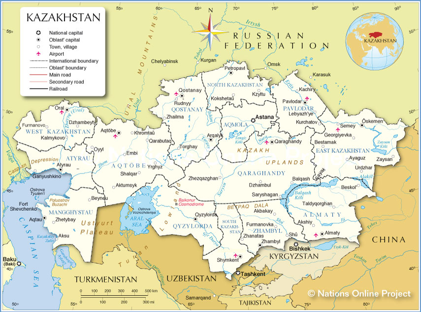 Administrative Map of Kazakhstan |
||||||
| More about Kazakhstan: Cities: Country: Kazakhstan key statistical data. Continent: |
Current Weather Conditions Astana
|
Related Consumer Information:
|
||||
Countries in Central Asia: Maps of Countries in Central Asia: Kazakhstan Political Map | Kazakhstan Administrative Map | Kyrgyzstan Political Map | Kyrgyzstan Administrative MapTajikistan Political Map | Tajikistan Administrative Map | Turkmenistan Political Map | Turkmenistan Administrative Map | Uzbekistan Political Map | Uzbekistan Administrative Map Searchable Maps of Countries in Central Asia: Kazakhstan interactive Map | Kyrgyzstan interactive Map | Tajikistan interactive Map Turkmenistan interactive Map | Uzbekistan interactive Map All Countries of the World |
One World - Nations Online .:. let's care for this planet Promote that every nation assumes responsibility for our world. Nations Online Project is made to improve cross-cultural understanding and global awareness. More signal - less NOISE |
| Site Map
| Information Sources | Disclaimer | Copyright © 1998-2023 :: nationsonline.org |
