
| Home |
|
|
|
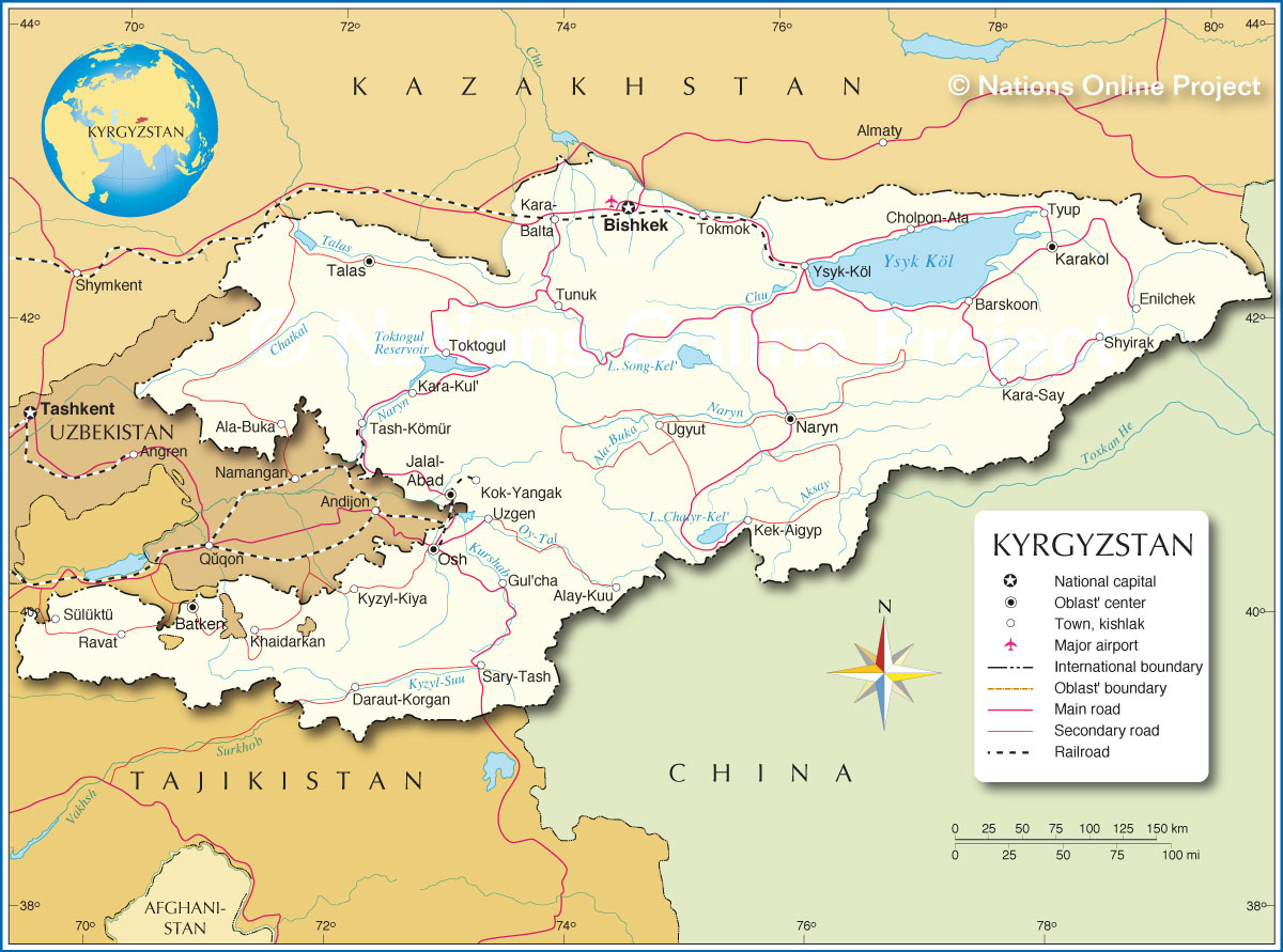
___ Political Map of Kyrgyzstan, Kyrgyz Republic or also Kirghizia |
|
About Afghanistan |
|
| Map is showing Kyrgyzstan, a landlocked mountainous country in Central Asia. Border countries are Kazakhstan to the north, People's Republic of China to the southeast, Tajikistan to the southwest, and Uzbekistan to the west. Capital city is Bishkek. Depicted on the map are cities, towns, and villages (see below), main roads, and Manas International Airport (IATA code: FRU), Kyrgyzstan’s primary airport. |
 Bookmark/share this page |
 One World - Nations Online all countries of the world |
|
|
||
 Political Map of Kyrgyz Republic |
|||||||
| Cities and Towns in Kyrgyzstan Depicted on the map are the location of following Kyrgyzstan cities and towns: Ala-Buka, Alay-Kuu, Barskoon, BISHKEK, Cholpon-Ata, Daraut-Korgan, Enilchek, Gul'cha, Jalal-Abad, Kara-Balta, Karakol (formerly: Przheval'sk), Ravat, Kara-Kul', Kara-Say, Kek-Aigyplö, Khaidarkan, Kok-Yangak, Kyzyl-Kiya, Naryn, Osh, Sary-Tash, Shyirak, Sülüktü (Sulyukta), Talas, Tash-Kömür, Tokmok, Toktogul, Tunuk, Tyup, Ugyut, Uzgen, and Ysyk Köl (Issyk Kul). |
More about Kyrgyzstan: Kyrgyzstan key statistical data. Reference Map of Southwestern Asia and the Middle East. |
Current Weather Conditions Bishkek
|
Related Consumer Information:
|
||||
Other Countries in Central Asia: Maps of Countries in Central Asia: Afghanistan Map | Kazakhstan Map | Tajikistan Map | Turkmenistan Map | Uzbekistan Map |
|||||||
One World - Nations Online .:. let's care for this planet Every nation is responsible for the current state of our world. |
| Site Map
| Information Sources | Disclaimer: Privacy Policy, etc. Contact: [email protected] | Copyright © 1998-2021 :: nationsonline.org |
