Nations Online
All Countries in the World
Nations Online All Countries in the World | |
Home  |
___ Satellite View and Map of the City of Samarkand, Uzbekistan |
About SamarkandSatellite view is showing Samarkand (also Samarqand), it the second-largest city in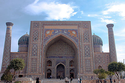 The Sher Dor Madrasah, part of the Registan in Samarkand Image: Tchumbley Today Samarkand has a population of about 500,000 people. Official language is Uzbek, but the majority of the city's inhabitants are Persian-speaking Tajiks. Just zoom in (+) to see the Registan, open public space, with its three madrasahs (institutions of learning). The Registan is located in the center of this ancient city. It is a major tourist attraction in Samarkand. The map shows a city map of Samarkand with expressways, and main roads, zoom out to find the location of Samarkand Airport (IATA code: SKD) north of the city center on the periphery of Samarkand. To find a location use the form below. |
|
| To find a location type: street or place, city, optional: state, country. |
Local Time Samarkand:
Saturday-April-27 23:09
Time zone: Uzbekistan Time (UZT) :: UTC/GMT +5 hours |
|
φ Latitude, λ Longitude (of Map center; move the map to see coordinates): , |
||||||
| Google Maps: Searchable map/satellite view of Samarkand, Uzbekistan. City Coordinates: 39°39′15″N 66°57′35″E |
Bookmark/share this page |
|||||
| More about Uzbekistan: Cities: Country: Uzbekistan key statistical data. Continent: External Link Wikipedia: Samarkand |
Weather Conditions Samarkand
|
Related Consumer Information:
|
||||
Other Cities in South-Central Asia: Almaty, Ashgabat, Astana, Baku, Bishkek, Colombo, Dhaka, Dushanbe, Islamabad, Kabul Kathmandu, Male, New Delhi, Tehran, Thimphu |
||||||
Map Help [ show ] |
||||||
One World - Nations Online .:. let's care for this planet Promote that every nation assumes responsibility for our world. Nations Online Project is made to improve cross-cultural understanding and global awareness. More signal - less NOISE |
| Site Map
| Information Sources | Disclaimer | Copyright © 1998-2023 :: nationsonline.org |

