
|
|
___ Political and Administrative Map of Mali |
|
Map is showing Mali and the surrounding countries with international borders, provinces boundaries, the national capital Bamako, province capitals, major cities, main roads, railroads and main airports. Mali is a landlocked country in interior Western Africa, parts in the north reach deep into the middle of the Sahara desert, while its central parts are in the semi-arid Sahel zone, the transition zone between the Sahara in north and the Sudanian Savannas in south. The majority of Mali's population of 16.3 million (in 2016) live in the country's southern region. The country's area is more than two times the size of that of France or slightly less than twice the size of the area of the U.S. state of Texas. Since beginning of 2012, the Malian government has lost more and more control over the northern regions of Gao, Kidal, Tomboctou, and parts of northern Mopti. In April 2012 Tuare-led rebels have conquered the historic city of Timbuktu and the northern part of the country, from which at least half the population has fled either into the southern part of Mali or into neighbouring countries. The Tuareg are Berber people, they are the principal inhabitants of the interior of the Saharan desert. The Tuareg declared independence from Mali and named the new state Azawad, which means 'the land of the nomads'. Border Countries: Algeria, Burkina Faso, Guinea, Cote d'Ivoire, Mauritania, Niger, and Senegal Administrative regions of Mali Mali is divided into eight regions (régions) and one capital district. The regions are named after their region capitals: Gao, Kayes, Kidal, Koulikoro, Mopti, Ségou, Sikasso, Tomboctou (Timbuktu), and Bamako the capital district. |
 Bookmark/share this page |
 One World - Nations Online All Countries of the World |
|
|
||
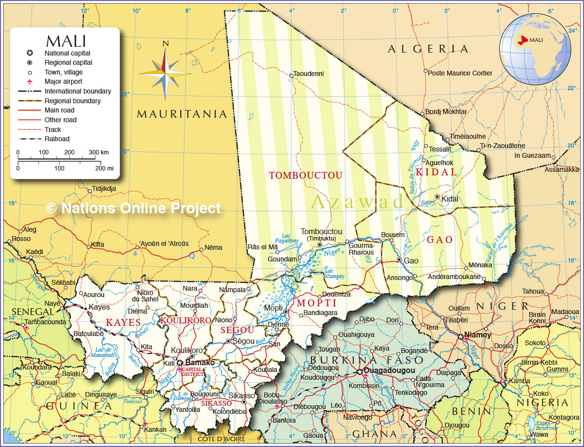 Political and Administrative Map of Mali Map based on a UN map. Source: UN Cartographic Section | |||||||
| Mali's cities and towns Depicted on the map are the location of following cities and villages in Mali. Largest cities (2009): Bamako (capital; 1.8 million), Sikasso (225,000), Koutiala (137,919), Ségou (130,690) Tombouctou population: 55,000 Other cities and villages: Aguelhok, Andéramboukane, Ansongo, Aourou, Bafoulabé, Bandiagara, Bougouni, Bourem, Diéma, Djenné, Douentza, Gao, Goundam, Gourma-Rharous, Kati, Kayes, Kidal, Kita, Kolondiéba, Koulikoro, Ménaka, Mopti, Mourdiah, Nampala, Nara, Niono, Nioro du Sahel, Râs el Mâ, San, Taoudenni, Tessalit, Tombouctou (Timbuktu), and Yanfolila. |
More about Mali Cities: Country: Continent: |
Bamako Current Weather Conditions
|
Related Consumer Information: |
||||
Political Maps of other Countries in West Africa: Benin Map | Burkina Faso Map | Cape Verde Map | Côte d'Ivoire Map | Ghana Map | Guinea Map | Guinea-Bissau Map Liberia Map | Mauritania Map | Niger Map | Nigeria Map | Senegal Map | Sierra Leone Map | Togo Map |
|||||||
One World - Nations Online .:. let's care for this planet Every nation is responsible for the current state of our world. |
| Site Map
| Information Sources | Disclaimer: Privacy Policy, etc. Contact: [email protected] | Copyright © 1998-2021 :: nationsonline.org |
