Nations Online
All Countries in the World
Nations Online All Countries in the World | |
Home  |
___ Satellite View of Antarctica |
 The Antarctica without the ice. Until now no sign of a lost civilisation from times after the continent detached from Gondwana supercontinent. But the continent is huge, more than 25 times the size of France, and when you use the map below you have to zoom in a lot to find any sign of human activity. Image: NASA |
Satellite View of Antarctica using Google Earth DataSatellite view is showing Antarctica, the most unknown place on this planet. Earth's southernmost continent is located around the South Pole, the southern point of Earth's rotation axis. Antarctica lies within the Antarctic Circle, it is bordered by the Antarctic ocean also known as the Southern Ocean. The whole continent is almost entirely covered by ice sheets, permanent layers of frozen water.Oh, and yes, sorry, Google Maps uses a close variant of the Mercator map projection, so it hardly show areas around the poles, you only can see the "peeled" version of the Antarctica (see the small world map on the right). So anyway, you may zoom in to explore this cool continent, or you may use Google Earth View of Antarctica. Zoom out to find the location of Antarctica's highest mountain or one of Antarctica's Ice streams, the Lambert Glacier, the world's largest glacier. It drains 8 % of the Antarctic ice sheet to the east and south of the Prince Charles Mountains. You also may find the strange Red Line near South Pole. To find a location use the form below. |
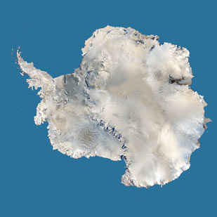 Satellite image of Antarctica Image: courtesy of NASA 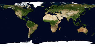 Mercator world map projection, Antarctica in south. |
| To find a location type: street or place, city, optional: state, country. |
Local Time South Pole:
Tuesday-July-7 15:04
New Zealand Standard Time (NZST) UTC+12 |
|
φ Latitude, λ Longitude (of Map center): , |
||||||
| Google Earth Antarctica: South Pole - Searchable Satellite View of the southernmost Continent. |
Bookmark/share this page |
|||||
| Related Topics: Physical Map of Antarctica. Map is showing the world's continents and regions. World map showing independent states borders, dependencies or areas of special sovereignty, islands and island groups as well as capital cities. Shaded relief map of the world, showing landmasses, continents, oceans, regions, mountain ranges, islands and island groups as well as extreme points. |
Weather Conditions South Pole:
|
Related Consumer Information:
|
||||
Map Help [ show ] |
||||||
One World - Nations Online .:. let's care for this planet Promote that every nation assumes responsibility for our world. Nations Online Project is made to improve cross-cultural understanding and global awareness. More signal - less NOISE |
| Site Map
| Information Sources | Disclaimer | Copyright © 1998-2024:: nationsonline.org |

