Nations Online
All Countries in the World
|
One Planet Nations Online All Countries in the World | |
| Home |
___ Administrative Map of Panama |
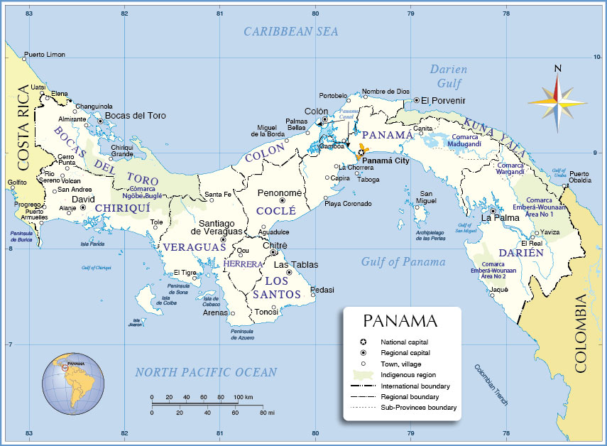
Map is showing Panama, the southernmost country of Central America, located on the Isthmus of Panama, a landbridge between the Caribbean Sea (Atlantic Ocean) and the Pacific Ocean. Isthmus of Panama links the continents of North and South America. Panama is bordered by the Central American country of Costa Rica in west and the South American Colombia in east. Administrative Regions of the Republic of PanamaMap shows Panama's administrative divisions of nine provinces (provincias) and its three provincial-level indigenous regions (comarcas indígenas).The provinces are (province capital in parentheses): Bocas del Toro (Bocas del Toro), Chiriquí (David), Coclé (Penonomé), Colón (Colón), Darién (La Palma), Herrera (Chitré), Los Santos (Las Tablas), Panamá (Panamá), and Veraguas (Santiago de Veraguas). The comarcas are (comarca capital in brackets): Emberá (Union Choco), Kuna Yala, formerly known as San Blas (El Porvenir), Ngöbe-Buglé (Chichica). The map also shows the location of the Panama Canal (about 80 km (50 mi) long), running north to south across the Isthmus of Panama, and connects the Caribbean Sea (Atlantic) with the Gulf of Panama (Pacific Ocean). Click on the map to enlarge.  Administrative Map of Panama |
One World - Nations Online .:. let's care for this planet Promote that every nation assumes responsibility for our world. Nations Online Project is made to improve cross-cultural understanding and global awareness. More signal - less NOISE |
| Site Map
| Information Sources | Disclaimer | Copyright © 1998-2023 :: nationsonline.org |