
| Home |
|
|
|
___ Administrative Map of Nicaragua |
|
About Nicaragua |
|
| Nicaragua is a Central American country bordering both the Caribbean Sea (Atlantic Ocean) and the North Pacific Ocean. It is bordered by Costa Rica and Honduras, and it shares maritime borders with Colombia and El Salvador. Nicaragua is the largest country in Central America, it occupies an area of 130,370 km², compared it is somewhat larger than half the size of the United Kingdom or slightly smaller than New York state. Eye-catching on the map is the large lake in the south of the country, Lago de Nicaragua (Lake Nicaragua), it is the largest freshwater lake in Central America. Highest point in the country is the peak of Cerro Mogoton, the stated elevation might be incorrect – figures vary between 2,094 m, 2,107 m and 2,438 m above sea level, but anyway making Pico Mogoton the highest mountain in Nicaragua. Nicaragua has a population of 6 million people (official estimate 2010). Capital and largest city is Managua. Spoken languages are Spanish (official), and several regional recognized languages like Miskito, Rama, Sumo, Miskito Coastal Creole, Garifuna, and Rama Cay Creole. Map is showing Nicaragua and the surrounding countries with international borders, provincial boundaries, the national capital Managua, provincial capitals, major cities, main roads, railroads and major airports. |
 Bookmark/share this page |
 One World - Nations Online All Countries of the World |
|
|
||
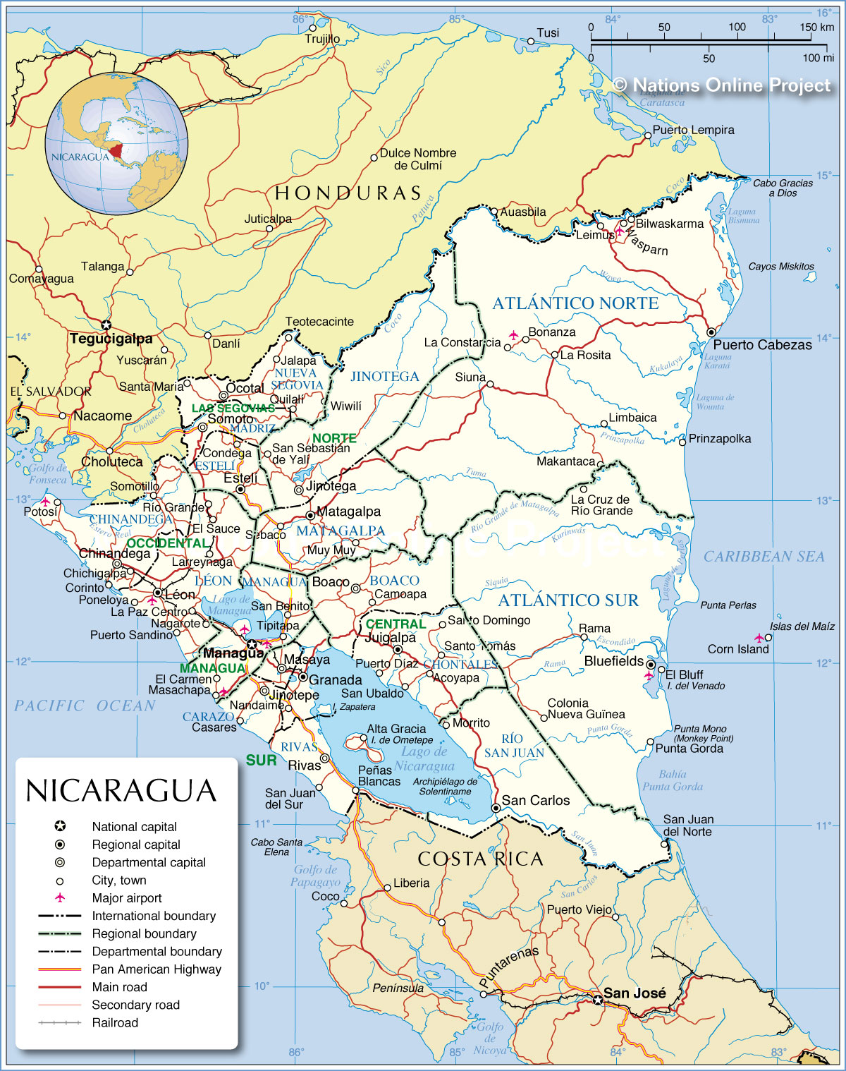 Administrative Map of Nicaragua Map based on a UN map. Source: UN Cartographic Section |
|||||||
| Departments of Nicaragua: The map shows Nicaragua's 15 departments (departamentos) and the two self-governing autonomous regions (capitals in parentheses): Departments: Boaco (Boaco), Carazo (Jinotepe), Chinandega (Chinandega), Chontales (Juigalpa), Estelí (Estelí), Granada (Granada), Jinotega (Jinotega), Leon (Leon), Madriz (Somoto), Managua (Managua), Masaya (Masaya), Matagalpa (Matagalpa), Nueva Segovia (Ocotal), Rivas (Rivas), Río San Juan (San Carlos). Autonomous regions: Región Autónoma del Atlántico Norte (Puerto Cabezas) Región Autónoma del Atlántico Sur (Bluefields) |
More about Nicaragua: Cities: Country: Continent: |
Managua Weather Conditions:
|
Related Consumer Information:
|
||||
| Maps of other Countries in Central America: Belize Map, Costa Rica Map, El Salvador Map, Guatemala Map, Honduras Map, Mexico Map, Panama Map Maps of Caribbean Islands Cuba Map, Dominican Republic, Haiti Map, Jamaica Map, Puerto Rico Map | |||||||
One World - Nations Online .:. let's care for this planet Every nation is responsible for the current state of our world. |
| Site Map
| Information Sources | Disclaimer: Privacy Policy, etc. Contact: [email protected] | Copyright © 1998-2021 :: nationsonline.org |
