Nations Online
All Countries in the World
Nations Online All Countries in the World | |
Home  |
___ Satellite View and Map of the town of Abyei (أبيي), Sudan |
About Abyei (town)Satellite view is showing Abyei, a town in the Abyei Area ofAbyei has a population of estimated 30-50,000 people. Spoken languages are predominantly Dinka and Sudanese Arabic. Abyei is a key town in the conflict between North- and South Sudan, "Abyei is the 'line in the sand' on which neither Khartoum nor Juba is willing to compromise." Clashes broke out in Abyei in December 2007 after the GoSS (Government of Southern Sudan) appointed an administrator for the region - a move rejected by local, pro-Northern Misseriya tribe (a branch of the Baggara Arabs tribes), who in reaction formed a group called the Abyei Liberation Front. Abyei town was almost completely destroyed in May 2008 when tensions escalated between the SPLA of the south and the Sudanese Army Force (SAF). Following the signing of the Comprehensive Peace Agreement (in 2005), which left the status of Abyei undecided, the region became a gateway for returnees, especially for Dinka, Ngok and Twic people. Up to May 2008, more than 60,000 returnees have resettled in Abyei, about fifteen new villages were re-established in the area, and several markets were either expanded or opened. However, due to the conflict, the Abyei area suffered greatly from a lack of access to basic social services such as drinking water, schools and health facilities, as well as from the absence of governance and rule of law institutions. This has made the resettlement process very challenging for the returning population. (UNDP) In May 2011 Abyei was seized by Khartoum government troops, caused widespread looting and some 40,000 people have fled the fighting around Abyei - mostly southerners, heading further south. The map shows a town map of Abyei with motorways, main roads and streets. To find a location use the form below. | 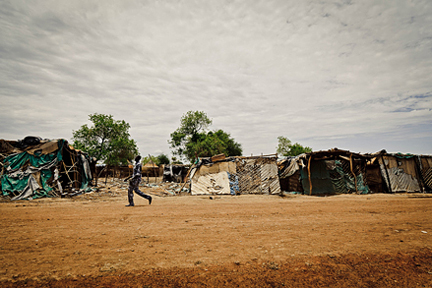 A Southern Sudanese soldier walks past the Aniet market in Agok in Abyei region. Residents of the town have fled after Sudan Armed forces occupied Abyei town and threatened to push southward. Image: ENOUGH Project © All Rights Reserved 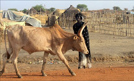 Cattle are central to the lives of tribesmen in Abyei region. Image: AFP |
| To find a location type: street or place, city, optional: state, country. |
Local Time Sudan:
Friday-April-26 12:01
Eastern Africa Time (EAT): UTC/GMT +3 hours |
|
φ Latitude, λ Longitude (of Map center; move the map to see coordinates): , |
||||||
| Google Maps: Searchable map/satellite view of Abyei, Republic of the Sudan. |
Bookmark/share this page |
|||||
| More about Sudan: Cities: (capital city of South Sudan) Country: Continent: External Links: UNHCR Refworld: Sudan: Fighting could hamper Abyei aid operation (2008) ENOUGH Project Satellite images and photos of Abyei region. Wikipedia: Abyei (region) Wikipedia: Abyei (town) | Sudan Current Weather Conditions:
|
Related Consumer Information:
| ||||
| Countries and Territories of Africa | ||||||
Map Help [ show ] |
||||||
One World - Nations Online .:. let's care for this planet Promote that every nation assumes responsibility for our world. Nations Online Project is made to improve cross-cultural understanding and global awareness. More signal - less NOISE |
| Site Map
| Information Sources | Disclaimer | Copyright © 1998-2023 :: nationsonline.org |

