Nations Online
All Countries in the World
Nations Online All Countries in the World | |
Home  |
___ Satellite View and Map of the City of Port Moresby (Pot Mosbi), Papua New Guinea |
Searchable Map and Satellite View of Port Moresby using Google Earth Data Satellite view is showing Port Moresby, since 1975 the national capital of Satellite view is showing Port Moresby, since 1975 the national capital of Port Moresby has a population of about 350,000 inhabitants. Main languages are Tok Pisin (New Guinea Pidgin, an English based Creole), English, and Motu. The city is home to the Parliament of Papua New Guinea, the National and the Supreme Court, and the University of Papua New Guinea, all located in Waigani, a suburb north of Port Moresby. Nearby are the PNG National Museum, and the National Library. The map shows a city map of Port Moresby with expressways, main roads and streets, zoom out to find the location of Jacksons International Airport To find a location use the form below. |
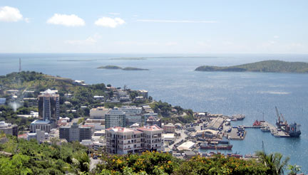 Overlooking Port Moresby from Touaguba Hill. Image: M. Schlauch Bookmark/share this page |
| To find a location type: street or place, city, optional: state, country. |
Local Time Papua New Guinea:
Friday-April-26 16:48
Time zone: Papua New Guinea Time (PGT) UTC/GMT + 10 hours |
|
φ Latitude, λ Longitude (of Map center; move the map to see coordinates): , |
||||||
| Google Earth: Satellite View of Port Moresby, Papua New Guinea. |
||||||
| More about Papua New Guinea: Cities: Country: Continent: External Links: Port Moresby Capital District (official website) Papua New Guinea Today Local news. Wikipedia: Port Moresby |
Current Weather Conditions Port Moresby:
|
Related Consumer Information:
|
||||
Other Melanesian Island Nations and Territories: Fiji, New Caledonia, Solomon Islands, Vanuatu |
||||||
Map Help [ show ] |
||||||
One World - Nations Online .:. let's care for this planet Promote that every nation assumes responsibility for our world. Nations Online Project is made to improve cross-cultural understanding and global awareness. More signal - less NOISE |
| Site Map
| Information Sources | Disclaimer | Copyright © 1998-2023 :: nationsonline.org |

