Nations Online
All Countries in the World
Nations Online All Countries in the World | |
Home  |
___ Satellite View and Map of Maldives (Dhivehi Raajjeyge Jumhooriyyaa) |
Searchable Map and Satellite View of Maldives using Google Earth DataSatellite view is showing the Maldives a southern Asian chain of coral islands and atolls in the Indian Ocean, south-southwest ofThe Maldives has a population of about 300,000 inhabitants. Capital city is Male. Spoken language is Dhivehi (Mahl). Administrative Divisions: 1 other first-order administrative division: Maale (Malé) and 19 atolls: Alifu, Baa, Dhaalu, Faafu, Gaafu Alifu, Gaafu Dhaalu, Gnaviyani, Haa Alifu, Haa Dhaalu, Kaafu, Laamu, Lhaviyani, Meemu, Noonu, Raa, Seenu, Shaviyani, Thaa, and Vaavu. The map shows Maldives with cities, towns, expressways, main roads and streets. To find a location use the form below. |
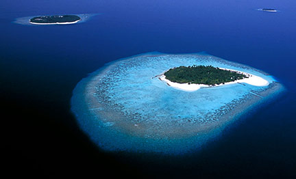 The Maldives consists of 1190 coral islands grouped into about 26 atolls spread over 90,000 square kilometers (only 1% is land). Image: Maldives |
| To find a location type: street or place, city, optional: state, country. |
Local Time Maldives:
Friday-May-3 14:41
Time zone: Maldives Time (MVT) :: UTC/GMT +5 hours |
|
φ Latitude, λ Longitude (of Map center; move the map to see coordinates): , |
||||||
| Google Maps: Searchable Map of Maldives. | ||||||
| More about the Maldives: Cities: Country: Continent: | Current Weather Conditions Male
|
Related Consumer Information:
|
||||
Countries and Territories of Asia Countries of the World: A - C | D - G | H - L | M - P | Q - T | U - Z Continents: Africa | The Americas | Australia/Oceania | Europe |
||||||
|
Search Nations Online Project
|
Bookmark/share this page
|
One World - Nations Online .:. let's care for this planet Promote that every nation assumes responsibility for our world. Nations Online Project is made to improve cross-cultural understanding and global awareness. More signal - less NOISE |
| Site Map
| Information Sources | Disclaimer | Copyright © 1998-2023 :: nationsonline.org |

