Nations Online
All Countries in the World
Nations Online All Countries in the World | |
Home  |
___ Satellite View and Map of the City of Wellington, New Zealand |
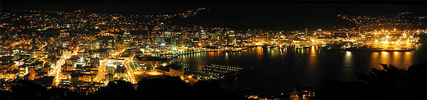 Panorama view of Wellington Harbor at night, New Zealand's capital. Image: Donovan Govan |
About Wellington Satellite view is showing Wellington, third most populous city and the national capital of Satellite view is showing Wellington, third most populous city and the national capital of 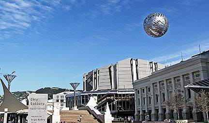 Wellington's renowned sculpture Ferns over Civic Square, a popular public square in Wellington. Image: Donaldytong Some points of interest in Wellington: Museum of New Zealand Te Papa Tongarewa (national museum); Wellington Museum (the history of Wellington in the historical Bond Store building); Adam Art Gallery (houses the Victoria University Art Collection); City Gallery (art gallery); Wellington Cable Car, connects Lambton Quay, the main shopping street with Kelburn station the entry to Wellington's Botanical Garden and Space Place at Carter Observatory. Wellington Town Hall (concert venue); Michael Fowler Centre (concert hall and convention center); Wellington Zoo (100 years old, the country’s first zoo); Princess Bay (beach). The Map shows a city map of Wellington with expressways, main roads and streets, and the location of Wellington International Airport (IATA Code: WLG), about 7 km by road (via State Highway 1) south east of the city. To find a location use the form below. |
| To find a location type: street or place, city, optional: state, country. |
Local Time New Zealand:
Friday-April-26 03:25
New Zealand Standard Time (NZST) UTC+12New Zealand Daylight Time (NZDT) UTC+13 from end of September until the first Sunday in April |
|
φ Latitude, λ Longitude (of Map center; move the map to see coordinates): , |
||||||
| Sorry! Google's pricing policy has made it impossible for us to continue showing Google Maps. We apologize for any inconvenience. Google Map: Searchable map/satellite view of Wellington, New Zealand's capital city. City Coordinates: 41°17′20″S 174°46′38″E |
Bookmark/share this page |
|||||
| More about New Zealand: Landmarks: Cities: Country: Continent: External Links: Wellington (official tourism web site) Wellington Daily News Local news. Wikipedia: Wellington |
Weather Conditions Wellington
|
Related Consumer Information:
|
||||
Countries and territories of Australia/Oceania |
||||||
Map Help [ show ] |
||||||
One World - Nations Online .:. let's care for this planet Promote that every nation assumes responsibility for our world. Nations Online Project is made to improve cross-cultural understanding and global awareness. More signal - less NOISE |
| Site Map
| Information Sources | Disclaimer | Copyright © 1998-2023 :: nationsonline.org |

