Nations Online
All Countries in the World
Nations Online All Countries in the World | |
Home  |
___ Satellite View and Map of London's Tower Bridge |
Satellite View of London using Google Earth DataSatellite view is showing the Tower Bridge of London straddling the River Thames. The combined suspension and double-leaf bascule bridge was built from 1886 until 1894.The Tower Bridge consists of two towers connected at the upper level by two horizontal walkways and movable double leafs at the lower level, to facilitate navigation. The monument is a world-renowned symbol of London. London Bridge, which is the next bridge upstream, was originally the only crossing for the Thames. In the 19th century, the East End of London has become so densely populated and commercial development has increased so that the public need for a new bridge to the east of London Bridge has mounted and the construction of a new bridge was inevitable. A traditional fixed bridge wasn't an option, because it would prevent access to the port facilities in the Pool of London by then used by ocean-going tall-masted ships and merchant vessel. The City of London Corporation, responsible for this part of the Thames, went into action by forming the "Special Bridge or Subway Committee" in 1876, to find a solution to the river crossing problem. The Committee opened the design for the new crossing to public competition, over 50 designs were submitted. In 1884 the Committee has chosen the design of Horace Jones, the City Architect. The idea of a bascule suspension bridge with two towers built on piers was devised by Jones' engineer, John Wolfe Barry. Construction started in 1886, two massive piers were sunk into the riverbed to support the construction. 11,000 tons of steel provided the framework for the towers and walkways. The steel framework was clad in Cornish granite and Portland stone to protect the underlying steel and to give the bridge its appearance. Horace Jones died in 1887 and George D. Stevenson took over the project. He replaced Jones' original brick facade with a Victorian Gothic style. Total length: 244 m (800.5 ft), height: 65 metres (213 ft) To view the map, click on the "Map" button. |
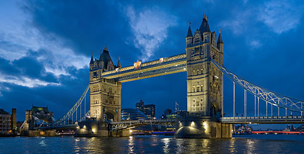 Tower Bridge of London straddling the River Thames. Image by Diliff 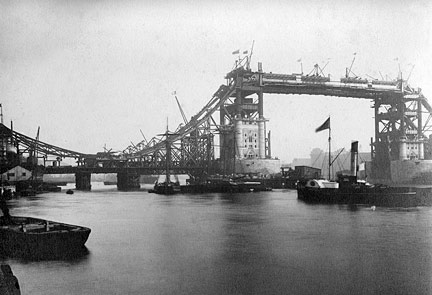 Tower Bridge construction works, 28th September 1892. Bookmark/share this page |
|
|
||
| Google Earth: map/satellite view of the Tower Bridge, London |
||
| More about the United Kingdom: Other Landmarks: Information and searchable city maps: Country: Continent: External Links: Tower Bridge Exhibition Official website of the monument. Wikipedia: Tower Bridge Wikipedia article about Tower Bridge. |
Explore more:
Related Consumer Information:
|
|
| Countries and Territories of Europe | ||
Map Help [ show ] |
||
One World - Nations Online .:. let's care for this planet Made to improve cross-cultural understanding, global awareness, and cultivating a cosmopolitan consciousness. |
 |
|
| Site Map
| Information Sources | Disclaimer: Privacy Policy, etc. | Contact:
[email protected]
Copyright © 1998-2017 :: nationsonline.org | ||
