
| Home |
|
|
|
___ Political Map of Papua New Guinea |
|
About Papua New Guinea |
|
| Papua New Guinea is a country in the western Pacific Ocean that includes the eastern half of the island of New Guinea as well as some neighboring islands. PNG is situated between the Coral Sea and the South Pacific Ocean, east of Indonesia and north of Australia. Papua's terrain consists mostly of mountains and rolling foothills covered with tropical rainforest, the New Guinea Highlands runs the length of the island of New Guinea. Dense rainforests can also be found in the coastal lowlands. Papua lies on the Pacific Ring of Fire and has a number of active volcanoes with frequent eruptions. Earthquakes are relatively common, rarely accompanied by tsunamis. The combined area of its islands are 462,840 km² (178,703 sq mi ), compared it is slightly larger than Sweden or also slightly larger than the U.S. state California. Papua's population counts about 7 million people (UN est. 2012) its capital and largest city is Port Moresby. Spoken languages are English (official), Tok Pisin (an English-based Creole), and several hundred native Austronesian and Papuan languages. Border Countries are Indonesia, and it shares maritime borders with Australia, the Federated States of Micronesia, Solomon Islands, and New Caledonia (France). Papua New Guinea was formed in 1949 from the administrative union of Papua, an Australian Territory since 1906, and the Trust Territory of New Guinea (Northeast New Guinea), which was formerly under German control and an Australian trusteeship since 1921. In 1975, it became an independent state within the Commonwealth of Nations. The map below is showing Papua New Guinea with international borders, provincial boundaries, the national capital, provincial capitals, major cities, main roads, railroads and major airports. |
 Papua New Guinea Provinces The primary administrative divisions of the country are 22 province-level divisions: twenty provinces, the Autonomous Region of Bougainville and the National Capital District. The provinces are (capital in parentheses): Manus (Lorengau), New Ireland (Kavieng), West Sepik (Sandaun; capital: Vanimo), East Sepik (Wewak), Madang (Madang), Enga (), Western Highlands (Mount Hagen), Southern Highlands (Mendi), Chimbu (Simbu; capital: Kundiawa), Eastern Highlands (Goroka), Morobe (Lae), West New Britain (Kimbe), East New Britain (Kokopo), Bougainville (temporarily Buka, Arawa), Western (Province or Fly River Province (Daru), Gulf (Kerema), Northern (or Oro Province; capital Popondetta), Central (Konedobu), and Milne Bay (Alotau). Bookmark/share this page |
 One World - Nations Online all countries of the world |
|
|
||
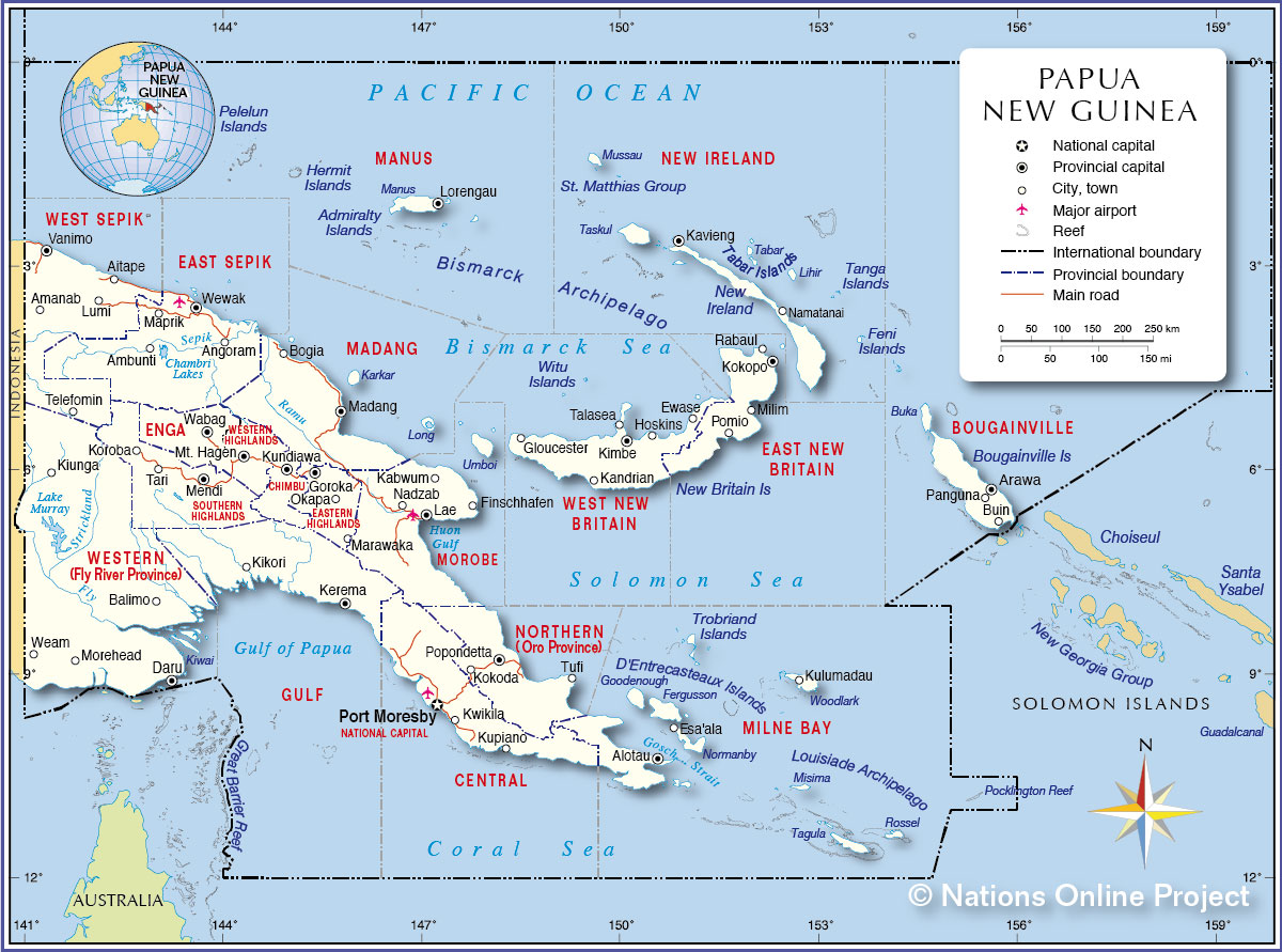 Political Map of Papua New Guinea Map based on a UN map. Source: UN Cartographic Section |
|||||||
| Cities and Towns in Papua New Guinea Map shows the location of following Papua New Guinean cities and towns: Aitape, Alotau, Amanab, Ambunti, Angoram, Arawa, Balimo, Bogia, Buin, Daru, Esa'ala, Ewase, Finschhafen, Gloucester, Goroka, Hoskins, Kabwum, Kandrian, Kavieng, Kerema, Kikori, Kimbe, Kiunga, Kokoda, Kokopo, Koroba, Kulumadau, Kundiawa, Kupiano, Kwikila, Lae, Lorengau, Lumi, Madang, Maprik, Marawaka, Mendi, Milim, Morehead, Mt. Hagen, Nadzab, Namatanai, Okapa, Panguna, Pomio, Popondetta, Port Moresby, Rabaul, Talasea, Tari, Telefomin, Tufi, Vanimo, Wabag, Weam, and Wewak. |
More about Papua New Guinea Cities: (capital city) Country: Continent: |
Current Weather Conditions Port Moresby:
|
Related Consumer Information: |
||||
Maps of other countries in Australia/Oceania and the Pacifics: Australia Map, New Caledonia Map, New Zealand Map, Samoa Map |
One World - Nations Online .:. let's care for this planet Every nation is responsible for the current state of our world. |
| Site Map
| Information Sources | Disclaimer: Privacy Policy, etc. Contact: [email protected] | Copyright © 1998-2021 :: nationsonline.org |
