Nations Online
All Countries in the World
Nations Online All Countries in the World | |
| Home |
___ Administrative Map of Namibia |
| Map is showing Namibia in South West Africa, with surrounding countries, states borders, the national capital, region borders, and region capitals. Namibia covers an area of 824,292 km² (318,260 sq. mi.), twice the size of Sweden, it is the second least densely populated country in the world (after Mongolia) with a population of 2 million people. Click for a Political Map of Namibia. 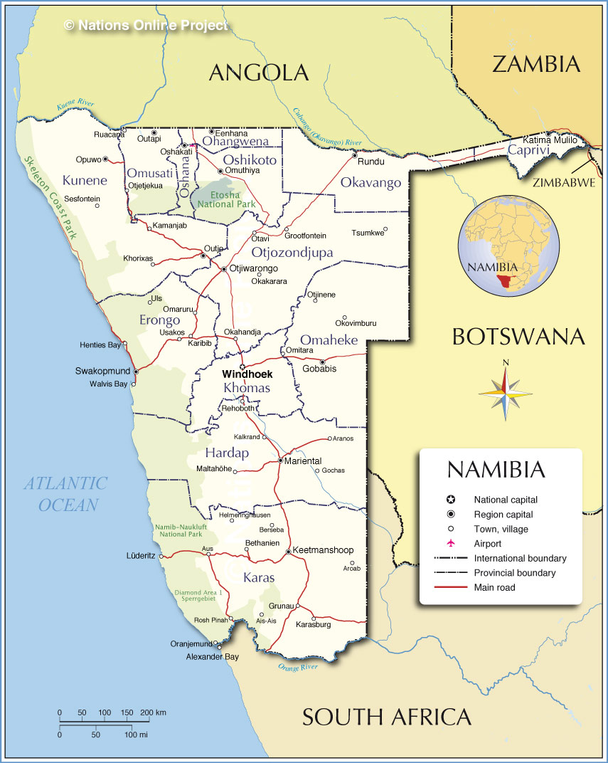 Administrative Map of Namibia |
||||||
| Administrative Regions of Namibia Namibia is divided into 13 regions (mkoa): The regions are (region capitals in parenthesis) Caprivi (Katima Mulilo), Erongo (Swakopmund), Hardap (Mariental), Karas (Keetmanshoop), Kavango (Rundu), Khomas (Windhoek), Kunene (Outjo), Ohangwena (Eenhana), Omaheke (Gobabis), Omusati (Outapi), Oshana, (Oshakati), Oshikoto (Omuthiya), Otjozondjupa (Otjiwarongo). | ||||||
| More about Namibia: Cities: Country: Continent: |
Weather Conditions Windhoek
|
Related Consumer Information:
|
||||
| Other Countries of Southern Africa: Botswana | Lesotho | South Africa | Swaziland Maps of other Countries of Southern Africa: Botswana Map | South Africa Map | Swaziland Map Searchable Maps of other Countries of Southern Africa: Botswana Interactive Map | Lesotho Interactive Map | South Africa Interactive Map | Swaziland Interactive Map Major Cities in Southern Africa: Bloemfontein | Cape Town | Durban | Gaborone | Johannesburg | Lobamba | Maseru | Mbabane | Nelspruit | Polokwane Port Elizabeth | Pretoria | Rustenburg | Windhoek |
||||||
One World - Nations Online .:. let's care for this planet Made to improve cross-cultural understanding, global awareness, and cultivating a cosmopolitan consciousness. |
 |
|
| Site Map
| Information Sources | Disclaimer: Privacy Policy, etc. | Contact:
[email protected]
Copyright © 1998-2017 :: nationsonline.org | ||
