Nations Online
All Countries of the World
Nations Online All Countries of the World |
|
Home  |
___ Administrative Map of Liberia |
| Map is showing Liberia, a West African country bordered in west by the North Atlantic Ocean, capital city is Monrovia. The map shows the country with international borders, regional boundaries, the national capital Dakar, regional capitals, cities and towns, and major airports. Border Countries: Guinea, Cote d'Ivoire (Ivory Coast), and Sierra Leone Click on the map to see a detailed map of Liberia. 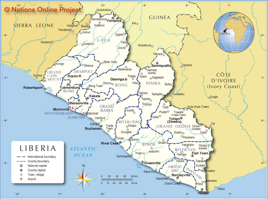 Administrative Map of Liberia Liberia is divided into 15 counties (capital towns/cities in parenthesis): Bomi (Tubmanburg), Bong (Gbarnga), Gbarpolu (Bopulu), Grand Bassa (Buchanan), Grand Cape Mount (Robertsport), Grand Gedeh (Zwedru (Tchien), Grand Kru (Barclayville), Lofa (Voinjama), Margibi (Kakata), Maryland (Harper), Montserrado (Bensonville) Nimba (Sanniquellie), River Cess (River Cess), River Gee (Fish Town), Sinoe (Greenville) |
||||||
| More about Liberia Cities: Country: Continent: |
Monrovia Current Weather Conditions at Roberts International Airport
|
Related Consumer Information:
|
||||
One World - Nations Online .:. let's care for this planet Made to improve cross-cultural understanding, global awareness, and cultivating a cosmopolitan consciousness. |
 |
|
| Site Map
| Information Sources | Disclaimer: Privacy Policy, etc. | Contact:
[email protected]
Copyright © 1998-2017 :: nationsonline.org | ||
