
| Home |
|
|
|
___ Map of Greenland |
|
About Greenland |
|
| Map is showing Greenland, since 1979 a self-governing overseas administrative division of Denmark. The largest island in the world is located between the North Atlantic and the Arctic oceans, north east of Canada. The island has an area of 2,166,086 km², making it the 12th largest country in the world, this is almost four times the size of France, or slightly more than three times the size of the U.S. state of Texas. More than two-thirds of Greenland lies within the Arctic Circle. Highest point is Gunnbjørn Fjeld with 3,700 m. Greenland has a population of 55,984 (Jan 2015). Capital is Nuuk, spoken languages are Greenlandic (Kalaallisut) an Eskimo–Aleut language and Danish. Greenland is covered by a flat to gradually sloping ice sheet which covers all but a narrow, mountainous, rocky coast. The icecap has an area of 1.75 million km² (almost the size of Mexico), with an average thickness of 2.3 km (1.4 mi), and holds estimated 7 percent of the world's freshwater. Greenland's more than fifty glaciers move ice from the interior of the island to the coast of the North Atlantic, where they break off as icebergs and eventually melt into the ocean. The Greenland ice sheet has been one of the largest contributors to global sea-level rise over the past 20 years. A significant portion of this contribution is associated with the speed-up of an increased number of glaciers in southeast and northwest Greenland. From 1996 to 2005 the velocity of many of Greenland's glaciers increased from 90 cubic km (22 cubic miles) per year to 220 cubic km (53 cubic miles) per year. 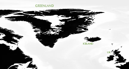 Topographic map of Greenland's bedrock. Black represents bedrock, white represents water at current level. Source: NASA and others |
 Bookmark/share this page 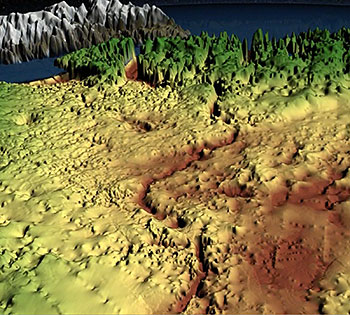 Hidden for all of human history, a 740 km (460 mi) long canyon has been discovered below Greenland's ice sheet. The subglacial canyon, carved into Greenland's bedrock was dubbed Greenland's 'Grand Canyon'. Image: NASA |
 One World - Nations Online all countries of the world |
|
|
||
Map of Greenland Map of Greenland |
|||||||
| Largest towns and settlements in Greenland: Nuuk (capital and largest city, pop.: 17,000), Sisimiut (formerly Holsteinsborg, second-largest town in Greenland with 5600 inhabitants, the majority descendants form Thule people, it is the administrative center of the Qeqqata Municipality) Ilulissat (formerly Jakobshavn; pop.: 4.500; the nearby Ilulissat Icefjord Qaqortoq (formerly Julianehåb; pop.: 3160; most populous town in southern Greenland; nearby is Hvalsey, Greenland's largest, best-preserved Norse ruins). Aasiaat (founded in 1759, located on Aasiaat island, at the southern end of Disko Bay; pop.: 3100). Maniitsoq (pop.: 2,670; the town is a port of call for the Arctic Umiaq ferry). Tasiilaq (one of the few towns on the eastern coast, pop.: 2100; Sermilik glaciology research station is located nearby, just 1 day on foot). Paamiut (formerly Frederikshåb; a town in southwestern Greenland in the Sermersooq municipality on the coast of the Labrador Sea). Narsaq (a town with a natural deep water harbor at the shore of Tunulliarfik Fjord; pop.: 1527). Nanortalik (the "Place Where the Polar Bears Go"; it is the southernmost town in Greenland with a population of 1260; this area was one of the first parts of Greenland settled by the Norse people) |
More about Greenland: Cities: Satellite View of Nuuk (Godthåb). Country: Satellite View and searchable map of Greenland. Continent: |
Current Weather Conditions Nuuk
|
Explore more:
Related Consumer Information:
|
||||
Maps of other Countries in Northern Europe Denmark Map, Estonia Map, Faroe Islands Map, Iceland Map, Ireland Map, Latvia Map, Lithuania Map, United Kingdom Map Interactive Maps of other countries and regions in Northern Europe: Denmark Interactive Map, Faroe Islands Interactive Map, Iceland Interactive Map, Ireland Interactive Map, Latvia Interactive Map, Lithuania Interactive Map, Norway Interactive Map, Scotland Interactive Map, Sweden Interactive Map, United Kingdom Interactive Map, Wales Interactive Map Major Cities in Northern Europe Belfast | Cardiff | Copenhagen | Dublin | Edinburgh | Glasgow | Helsinki | London | Moscow | Nuuk | Oslo Reykjavik | Riga | Saint Petersburg | Stockholm | Tallinn | Vilnius |
|||||||
One World - Nations Online .:. let's care for this planet Every nation is responsible for the current state of our world. |
| Site Map
| Information Sources | Disclaimer: Privacy Policy, etc. Contact: [email protected] | Copyright © 1998-2021 :: nationsonline.org |
