Nations Online
All Countries in the World
Nations Online All Countries in the World | |
Home  |
___ Satellite View and Map of Northern Mariana Islands |
Searchable Map and Satellite View of Northern Mariana Islands using Google Earth DataSatellite view is showing the three main islands Saipan, Tinian, and Rota, (from north to south), they are part of the Northern Mariana Islands, an archipelago, situated between the Philippine Sea (in west) and the North Pacific Ocean (in east) in Micronesia.The Commonwealth of the Northern Mariana Islands (NMI) is a self-governing entity in association with the United States, it consists of 16 islands of the Marianas with the exception of Guam. Six island of the NMI are inhabited, about 87,000 people live on the island chain. Capital city is Saipan (on the island Saipan). Official languages are English, Chamorro (especially in Guam and Saipan), and Carolinian (Refaluwasch). The map shows Northern Mariana Islands with cities, towns, and main roads. The Northern Mariana Islands share a maritime border with Japan. To find a location use the form below. Map Help |
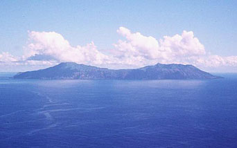 Aerial view of Anatahan Island, the uninhabited island is one of the most active volcanoes of the Northern Mariana Islands. |
| To find a location type: street or place, city, optional: state, country. |
Local Time Northern Mariana Islands:
Wednsday-April-17 23:28
UTC/GMT +10 hours |
|
φ Latitude, λ Longitude (of Map center; move the map to see coordinates): , |
||||||
| Google Maps: Searchable Map of Commonwealth of the Northern Mariana Islands. |
||||||
| More about Northern Mariana Islands: Capital: Islands: Country: Continent: | Current Weather Conditions Northern Mariana Islands
|
Related Consumer Information:
| ||||
| Other Micronesian Island Nations: Hawaii, Kiribati, Marshall Islands, Micronesia (Federated States of), Nauru, Northern Mariana Islands, Palau Countries and territories of Australia/Oceania Countries of the World: A - C | D - G | H - L | M - P | Q - T | U - Z Continents: Africa | The Americas | Asia | Europe |
||||||
Map Help [ show ] |
||||||
One World - Nations Online .:. let's care for this planet Promote that every nation assumes responsibility for our world. Nations Online Project is made to improve cross-cultural understanding and global awareness. More signal - less NOISE |
| Site Map
| Information Sources | Disclaimer | Copyright © 1998-2023 :: nationsonline.org |

