Nations Online
All Countries in the World
Nations Online All Countries in the World | |
Home  |
___ Satellite View and Map of the City of Sarajevo, Bosnia and Herzegovina |
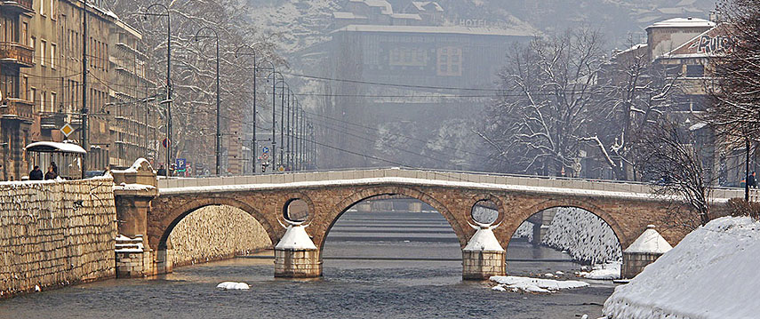 Latin Bridge in Sarajevo is a historic bridge over the River Miljacka. The bridge was the site of the assassination of Archduke Franz Ferdinand of Austria and his wife Sophie on 28 June 1914, the act sparked the outbreak of World War I. Latin Bridge in Sarajevo is a historic bridge over the River Miljacka. The bridge was the site of the assassination of Archduke Franz Ferdinand of Austria and his wife Sophie on 28 June 1914, the act sparked the outbreak of World War I.Image: Elooas |
About Sarajevo Satellite view is showing Sarajevo, largest city and the national capital of Satellite view is showing Sarajevo, largest city and the national capital of Sarajevo has a population of about 300,000 inhabitants. Spoken languages are Bosnian, Croatian, and Serbian (all official). It was the scene in June 1914 of the assassination of Archduke Franz Ferdinand (1863–1914), the heir to the Austrian throne, by a Bosnian Serb named Gavrilo Princip —an event that triggered the outbreak of World War I. The city suffered severely from the ethnic conflicts that followed the breakup of Yugoslavia in 1991 and was besieged by Bosnian Serb forces in the surrounding mountains 1992–94. The map shows a city map of Sarajevo with main roads and the location of Sarajevo International Airport (Butmir Airport; IATA code: SJJ), located about 6 km (4 mi) southwest of the city center. To find a location use the form below. |
||
| To find a location type: street or place, city, optional: state, country. |
Local Time Sarajevo:
Friday-April-19 06:04
Standard Time Zone (CET): UTC/GMT +1 hourDaylight Saving Time (CEST) in use from end of March until end of October: time zone offset: UTC/GMT +2 hours |
|
One World - Nations Online .:. let's care for this planet Promote that every nation assumes responsibility for our world. Nations Online Project is made to improve cross-cultural understanding and global awareness. More signal - less NOISE |
| Site Map
| Information Sources | Disclaimer | Copyright © 1998-2023 :: nationsonline.org |

