Nations Online
All Countries in the World
Nations Online All Countries in the World | |
Home  |
___ Satellite View and Map of Mexico City (Ciudad de México) |
 Satellite view is showing Mexico City (Spanish: Ciudad de México), the most important economic, industrial and cultural center and the national capital of Satellite view is showing Mexico City (Spanish: Ciudad de México), the most important economic, industrial and cultural center and the national capital of The city is located in the Valley of Mexico (Valley of Anáhuac), on the central Mexican plateau at an altitude of 2,240 m. Founded about 1300 AD as the Aztec capital Tenochtitlán, it was destroyed in 1521 by the Spanish conquistador Cortés, who rebuilt it as the capital of New Spain. Mexico's largest city has a population of more than 8.85 million inhabitants and more than 20.4 million live in its metropolitan area of Greater Mexico City, making it the second largest metropolitan area in the Americas. Official language is Spanish. The Map shows Mexico City with expressways, main roads and streets, and the location of Benito Juárez International Airport IATA Code: MEX). To find a location use the form below. |
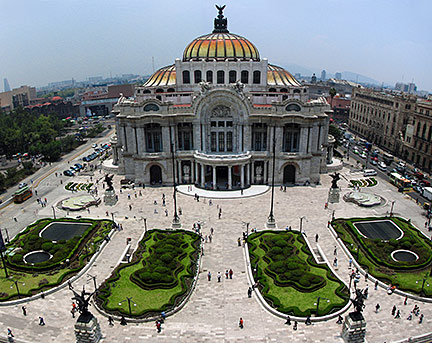 Palacio de Bellas Artes (Palace of the Fine Arts), downtown Mexico City. Photo: Carolina López Bookmark/share this page |
| To find a location type: street or place, city, optional: state, country. |
Local Time Mexico City:
Tuesday-April-23 23:06
Time zone: Central Daylight Time (CDT) UTC/GMT -6 hours |
|
φ Latitude, λ Longitude (of Map center; move the map to see coordinates): , |
||||||
| Sorry! Google's pricing policy has made it impossible for us to continue showing Google Maps. We apologize for any inconvenience. Google Map: Searchable map/satellite view of Mexico City (México D.F.), Mexico. |
||||||
| Mexico City Coordinates: 19°26′N 99°8′W |
||||||
| More about Mexico: Landmarks: Satellite View of Chichen Itza Country: Mexico key statistical data. Continent: World: |
Mexico City Current Weather:
External Links Mexico City (official website) Wikipedia: Mexico City |
Related Consumer Information:
|
||||
|
Other Cities in Central America: Belmopan, San José, San Salvador, Guatemala (City), Tegucigalpa, Managua, Panama (City) Searchable Maps of other Countries of Central America: Belize, Costa Rica, El Salvador, Guatemala, Honduras, Nicaragua, Panama |
||||||
Map Help [ show ] |
||||||
One World - Nations Online .:. let's care for this planet Promote that every nation assumes responsibility for our world. Nations Online Project is made to improve cross-cultural understanding and global awareness. More signal - less NOISE |
| Site Map
| Information Sources | Disclaimer | Copyright © 1998-2023 :: nationsonline.org |

