Nations Online
All Countries in the World
Nations Online All Countries in the World | |
Home  |
___ Satellite View and Map of the Eyjafjallajökull Volcano, Iceland |
Searchable Map of Eyjafjallajökull using Google Earth DataSatellite View is showing Eyjafjallajökull one of the smaller glaciers of Iceland. It is located 5 km (3.1 mi) off the island's southern Atlantic coast about 120 km southeast of Reykjavik, Iceland's capital city.The icecap of the glacier covers an active volcano 1,666 meters (5,466 ft) in height, its crater is 3–4 kilometers (1.9–2.5 mi) in diameter. The volcano has erupted relatively frequently since recorded history. An eruption in 1821 to 1823 caused a fatal glacial lake outburst flood. Most recently Eyjafjallajökull volcano erupted twice in 2010, on 20 March and 14 April. The March event forced a brief evacuation of around 500 local people, but the April eruption was ten to twenty times more powerful and caused massive disruption to air traffic across Northern and Western Europe. A huge swathe of European airspace was shut because of dangerous ash from the volcano. 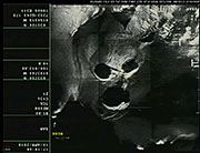 Radar observations at the Eyjafjallajökull eruption site, showing a strange image of holes in the glacier surface within the crater. The map shows a map of Southern Iceland with cities, expressways, main roads and streets. To find a location use the form below. To view just the map, click on the "Map" button. |
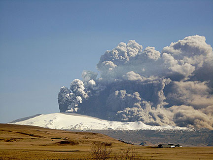 Eruption in Eyjafjallajökull. The volcano is covered by the Eyjafjallajökull glacier. Bookmark/share this page Image: Árni Friðriksson |
| To find a location type: street or place, city, optional: state, country. | Local Time Iceland:
Tuesday-April-23 09:15
UTC/GMT |
|
φ Latitude, λ Longitude (of Map center; move the map to see coordinates): , |
||||||
| Sorry! Google's pricing policy has made it impossible for us to continue showing Google Maps. We apologize for any inconvenience. Google Map: Searchable Map and Satellite View of the Eyjafjallajökull Volcano and Glacier, Iceland. |
||||||
| Coordinates 63°38′N 19°36′W |
||||||
| More about Iceland: Capital City of Iceland: Country: Continent: External Links: University of Iceland, Institute of Earth Sciences Facts and images about the Eruption in Eyjafjallajökull. NASA Earth Observatory Satellite image of the eruption of Eyjafjallajökull Volcano, Iceland. Wikipedia: Eyjafjallajökull Wikipedia article about Eyjafjallajökull. |
Current Weather Conditions near Eyjafjallajökull volcano:
|
Consumer Information:
|
||||
Map Help [ show ] |
||||||
One World - Nations Online .:. let's care for this planet Promote that every nation assumes responsibility for our world. Nations Online Project is made to improve cross-cultural understanding and global awareness. More signal - less NOISE |
| Site Map
| Information Sources | Disclaimer | Copyright © 1998-2023 :: nationsonline.org |

