Nations Online
All Countries in the World
Nations Online All Countries in the World | |
Home  |
___ Satellite View and Map of the City of Andorra la Vella |
About Andorra la Vella Satellite view is showing Andorra la Vella, the national capital of the Satellite view is showing Andorra la Vella, the national capital of the Andorra is a country, that is so small or great, that it would fit into one half of Berlin. 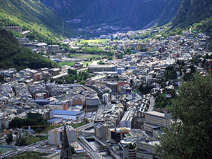 No, this is not the maintenance section of 'Elysium', the man-made space station from 2154, it's actually a photo of Andorra la Vella, the capital of Andorra. Andorra's capital has a population of about 23,000 people, this would make it a provincial town in other places, however there are some US state capitals with less inhabitants. The map shows a city map of Andorra la Vella with main roads and streets, and no, there is no airport in Andorra, next international airport is in Toulouse, France. To find a location use the form below. |
|
| To find a location type: street or place, city, optional: state, country. |
Local Time Andorra:
Monday-April-22 14:24
Standard Time Zone (CET): UTC/GMT +1 hourCEST (Daylight Saving Time) in use from end of March until end of October. Time zone offset: UTC/GMT +2 hours |
|
φ Latitude, λ Longitude (of Map center; move the map to see coordinates): , |
||||||
| Google Maps: Searchable map/satellite view of Andorra la Vella, Andorra. City Coordinates: 42°30′N 01°30′E |
Bookmark/share this page |
|||||
| More about Andorra: City: Country: Continent: External Links: Andorra la Vella Official site of Andorra's capital. Wikipedia: Andorra la Vella |
Weather Conditions Andorra: Nearest weather station at Perpignan, France
|
Related Consumer Information:
|
||||
Cities in the Mediterranean Athens, Florence, Istanbul, Lisbon, Ljubljana, Madrid, Monaco, Milan, Naples, Rome, San Marino, Tirana, Valletta, Vatican City, Venice, Zagreb Alexandria, Algiers, Beirut, Benghazi, Cairo, Jerusalem, Nicosia, Tripoli, Tunis, Tel Aviv Maps of other Countries in Southern Europe Croatia Map, Cyprus Map, Greece Map, Italy Map, Macedonia Map, Vatican City State Map Montenegro Map, Portugal Map, Serbia Map, Slovenia Map, Spain Map, Turkey Map Searchable Maps of other Countries in Southern Europe Croatia, Cyprus, Greece, Italy, Macedonia, Vatican City State Montenegro, Portugal, Serbia, Slovenia, Spain, Turkey Profiles of other Countries in Southern Europe Croatia, Cyprus, Greece, Italy, Macedonia, Vatican City State Montenegro, Portugal, Serbia, Slovenia, Spain, Turkey |
||||||
Map Help [ show ] |
||||||
One World - Nations Online .:. let's care for this planet Promote that every nation assumes responsibility for our world. Nations Online Project is made to improve cross-cultural understanding and global awareness. More signal - less NOISE |
| Site Map
| Information Sources | Disclaimer | Copyright © 1998-2023 :: nationsonline.org |

