Nations Online
All Countries in the World
Nations Online All Countries in the World | |
Home  |
___ Satellite View and Map of the City of Abidjan, Côte d'Ivoire |
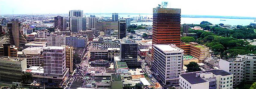 Skyline of Abidjan's Plateau District with the Ébrié Lagoon in background. Photo by: Zenman + Marku1988 |
About the City of AbidjanAbidjan is located on Ébrié Lagoon at the coast to the Gulf of Guinea (Atlantic Ocean). The city has a population of about 4 to 5 million inhabitants. Capital city of Côte d'Ivoire is Yamoussoukro. Spoken languages are French and Dioula (Bambara). 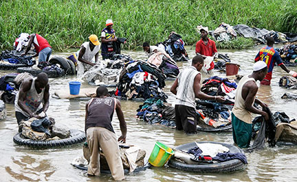 At the edge of Abidjan's Parc du Banco is a small river that serves as a wash-house, where the fanicos (laundry men) work, after collecting the laundry from the whole of the city. Image: Ferdinand Reus The Map shows a city map of Abidjan with expressways, main roads and streets, as well as the location of Abidjan International Airport named Felix Houphouet Boigny Airport (IATA Code: ABJ) southeast of the city center. The distance is 20 km (12.5 mi) by road (via Boulevard Valéry Giscard d'Estaing). To find a location use the form below. To see just the map click on the "Map" Button. |
|
| To find a location type: street or place, city, optional: state, country. |
Local Time Ivory Coast:
Monday-April-22 17:40
Time zone : Greenwich Mean Time (GMT) - No UTC/GMT offset |
|
φ Latitude, λ Longitude (of Map center; move the map to see coordinates): , |
||||||
| Sorry! Google's pricing policy has made it impossible for us to continue showing Google Maps. We apologize for any inconvenience. Google Map: Searchable map/satellite view of the city of Abidjan, Côte d'Ivoire. City Coordinates: 5°19′N 4°02′W |
Bookmark/share this page |
|||||
| More about Côte d'Ivoire: Cities: Country: Continent: |
Abidjan Weather Conditions:
External Link Abidjan International Airport Official website of Félix Houphouët-Boigny International Airport. Wikipedia: Abidjan |
Related Consumer Information:
|
||||
Other Major Cities in West Africa Abuja, Accra, Bamako, Banjul, Bissau, Conakry, Dakar, Freetown, Lomé, Monrovia, Niamey, Nouakchott, Ouagadougou, Porto-Novo, Praia, Yamoussoukro Searchable Maps of other Countries in West Africa: Benin | Burkina Faso | Cape Verde | Côte d'Ivoire | Gambia | Ghana | Guinea | Guinea-Bissau Liberia | Mali | Mauritania | Niger | Nigeria | Senegal | Sierra Leone | Togo |
||||||
Map Help [ show ] |
||||||
One World - Nations Online .:. let's care for this planet Promote that every nation assumes responsibility for our world. Nations Online Project is made to improve cross-cultural understanding and global awareness. More signal - less NOISE |
| Site Map
| Information Sources | Disclaimer | Copyright © 1998-2023 :: nationsonline.org |

