One World
Nations Online
One World Nations Online |
|
| Home |
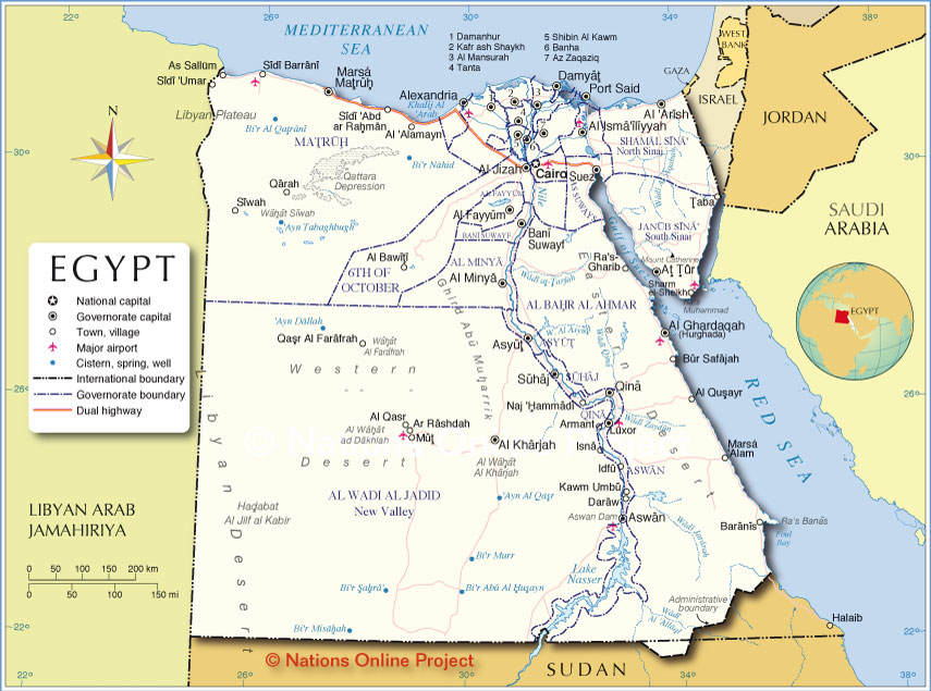
___ Administrative Map of Egypt |
| Map is showing state borders, governorate boundaries, the national capital Cairo, provincial capitals, cities, and major airports. Egypt's Primary Administrative Divisions Governorates of Egypt Egypt is divided into 29 governorates (muhafazah; Arabic: محافظة muḥāfaẓä, plural محافظات muhafazat). |
||||||
| The governorates are (capital city in brackets): Alexandria (Alexandria), Aswan (Aswan), Asyut (Asyut), Beheira (Damanhur), Beni Suef (Bani Suwayf, also Beni Suef), Cairo (Cairo), Dakahlia (Mansura), Damietta (Damietta, Damyat), Faiyum (Faiyum, Al Fayyum), Gharbia (Tanta), Giza (Giza; Al Jizah), Helwan (Helwan), Ismailia (Ismailia), Kafr el-Sheikh (Kafr el-Sheikh), Luxor (Luxor), Matruh (Mersa Matruh), Minya (Minya), Monufia (Shibin el-Kom or Shibin Al Kawm), El Wadi el Gedid or New Valley (Kharga, also El-Kharga', or Al-Kharijah), North Sinai (Arish), Port Said (Port Said), Qalyubia (Banha), Qena (Qena or Qina), Red Sea; Arabic: Al Bahr Al Ahmar (Al Ghardaqah, or Hurghada), Sharqia (Zagazig, Az Zaqaziq), Sohag (Suhaj, Sohag), South Sinai (el-Tor, also At Tur), Suez, Arabic: Assuways (Suez), 6th of October (6th of October) |
Bookmark/share this page |
|||||
 Administrative Map of Egypt |
||||||
| More about Egypt: Landmarks: Cities: Country: Egypt key statistical data. Continent: |
Current Weather Conditions Cairo:
External Links: Cairo Official website of Cairo Governorate. Cairo International Airport Official airport website. Wikipedia: Cairo Wikipedia entry for Cairo. |
Explore more:
Related Consumer Information:
|
||||
One World - Nations Online .:. let's care for this planet Made to improve cross-cultural understanding, global awareness, and cultivating a cosmopolitan consciousness. |
 |
|
| Site Map
| Information Sources | Disclaimer: Privacy Policy, etc. | Contact:
[email protected]
Copyright © 1998-2017 :: nationsonline.org | ||
