Nations Online
All Countries in the World
Nations Online All Countries in the World | |
Home  |
___ Administrative Map of Democratic Republic of the Congo |
| The Democratic Republic of the Congo is the second largest country in Africa (after Algeria). The country formerly known as Zaire is bordered by Angola, Burundi, Central African Republic, Republic
of the Congo, Rwanda, Sudan, Tanzania, Uganda, and Zambia, and it has a short coastline on the Atlantic Ocean. The country's long name is often shortened to DR Congo, Congo-Kinshasa or the DRC, it is not to be confused with neighboring Republic
of the Congo, also known as Congo-Brazzaville. Administrative divisions of the Democratic Republic of the Congo DR Congo's administrative divisions are ten provinces and one city-province. The provinces itself are subdivided into districts, these are divided into territories. The provinces are (capitals in parentheses): Bandundu (Bandundu, largest city Kikwit), Bas-Congo (Matadi), Équateur (Mbandaka), Kasai-Occidental (Kananga), Kasai-Oriental (Mbuji-Mayi), Katanga (Lubumbashi), Kinshasa (the city-province, largest city and capital of the country; formerly known as Léopoldville; pop. 9 million), Maniema (Kindu), Orientale (Kisangani), and the Kivus: North Kivu (Goma), South Kivu (Bukavu). Map is showing the Democratic Republic of the Congo with surrounding countries, administrative divisions, province capitals, cities, and towns. 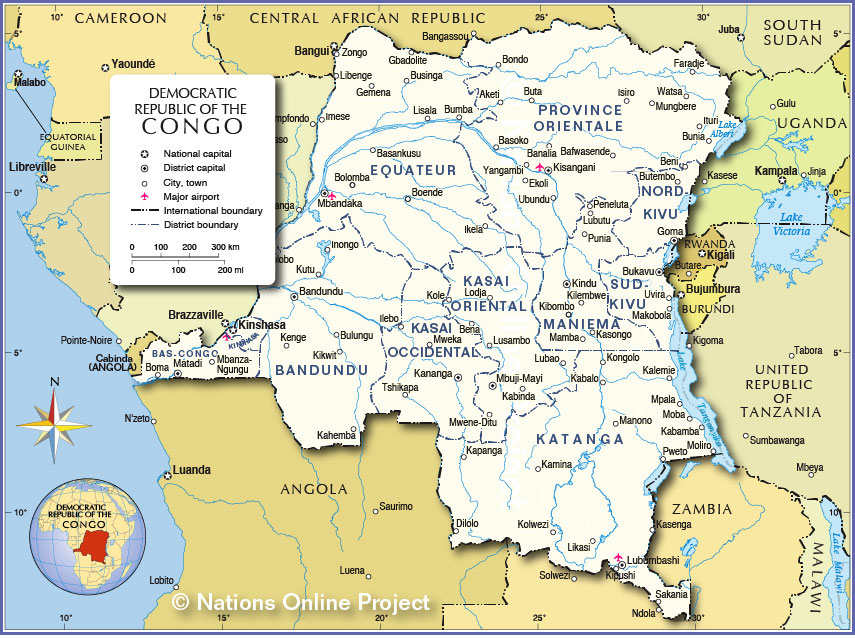
Administrative Map of Democratic Republic of the Congo |
| Countries and Territories of Africa |
One World - Nations Online .:. let's care for this planet Made to improve cross-cultural understanding and global awareness. |
| Site Map
| Information Sources | Disclaimer: Privacy Policy, etc. |
Contact:
[email protected]
| Copyright © 1998-2015 :: nationsonline.org |